Ruinerwold geodata
Ruinerwold (Drenthe) is a populated place; located in Netherlands in Europe/Amsterdam (GMT+2) time zone. With population of 2,485 people, there are 846 cities with bigger population in this country. Compared to other cities in Netherlands, 77.3% of cities are located further ↓South; 84.5% of cities are located further ←West and 74.9% of cities have higher elevation than Ruinerwold. Note1


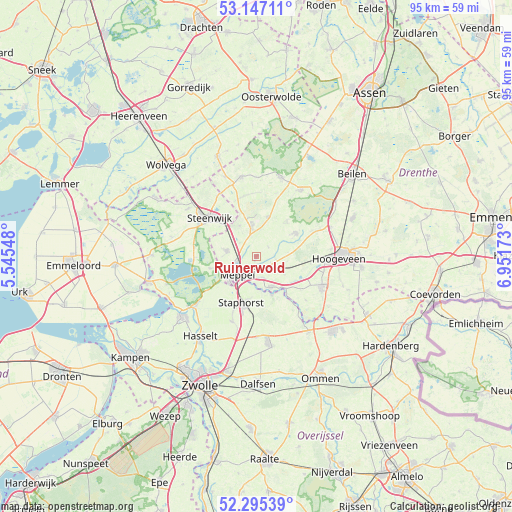
Ruinerwold GPS coordinates[2]
52° 43' 23.988" North, 6° 14' 54.996" East
| Map corner | latitude | longitude |
|---|---|---|
| Upper-left | 53.14711°, | 5.54548° |
| Center: | 52.72333°, | 6.24861° |
| Lower-right: | 52.29539°, | 6.95173° |
| Map W x H: | 94.7×94.7 km | = 58.8×58.8mi |
| max Lat: | 53.48025° ⇑22.7% North |
| Ruinerwold: | 52.72333° |
| min Lat: | ⇓77.3% South 50.76917° |
| min Long | Ruinerwold | max Long |
| 3.38611° | 6.24861° | 7.16528° |
| W 84.5%⇐ | ⇒15.5% E |
Elevation
Elevation of Ruinerwold is 2 m = 7 ft, and this is 13 m = 43 ft below average elevation for this country.
| Max E: |
203 m = 666 ft | 74.9% |
| Avg. | 15 m = 49 ft | |
| Ruinerwold | 2 m = 7 ft | |
Min E: |
-6 m = -20 ft | 25.1% |
See also: Netherlands elevation on elevation.city.
Geographical zone
Ruinerwold is located in North temperate zone (between Tropic of Cancer and the Arctic Circle). Distance of this North polar circle is 1538.9 km =956.2 mi to North.| Distance of | km | miles | from Ruinerwold |
|---|---|---|---|
| North Pole | 4144.8 | 2575.5 | to North |
| Arctic Circle | 1538.9 | 956.2 | to North |
| Tropic Cancer | 3256.4 | 2023.4 | to South |
| Equator | 5862.3 | 3642.7 | to South |


Nearby cities:
15 places around Ruinerwold: (largest is in red/bold)
• Belt-Schutsloot
13.7 km =8.5 mi,  245°
245°
• Darp
6.5 km =4 mi,  332°
332°
• De Wijk
6.2 km =3.9 mi,  153°
153°
• Giethoorn
11.6 km =7.2 mi,  279°
279°
• Havelte
5.2 km =3.2 mi,  353°
353°
• IJhorst
7.7 km =4.8 mi,  157°
157°
• Koekange
5.3 km =3.3 mi,  120°
120°
• Meppel
4.8 km =3 mi,  230°
230°
• Oostermeenthe
11.1 km =6.9 mi,  314°
314°
• Ruinen
8.3 km =5.2 mi,  58°
58°
• Staphorst
9.1 km =5.7 mi,  196°
196°
• Steenwijk
11.2 km =7 mi, 309°
• Tuk
13.2 km =8.2 mi, 308°
• Uffelte
7.7 km =4.8 mi,  16°
16°
• Zuidveen
11.3 km =7 mi,  302°
302°
Sources, notices
• [Note1] Compared only with cities in Netherlands existing in our database
• [Src1] Map data: © OpenStreetMap contributors (CC-BY-SA)
• [Src2] Other city data from geonames.org with taken over terms of usage.
• [Src3] Geographical zone / Annual Mean Temperature by Robert A. Rohde @ Wikipedia
