Meppel geodata
Meppel (Drenthe) is a populated place; located in Netherlands in Europe/Amsterdam (GMT+2) time zone. With population of 30,697 people, there are 104 cities with bigger population in this country. Compared to other cities in Netherlands, 76.4% of cities are located further ↓South; 82.9% of cities are located further ←West and 74.9% of cities have higher elevation than Meppel. Note1


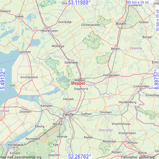
Meppel GPS coordinates[2]
52° 41' 44.988" North, 6° 11' 39.984" East
| Map corner | latitude | longitude |
|---|---|---|
| Upper-left | 53.11988°, | 5.49132° |
| Center: | 52.69583°, | 6.19444° |
| Lower-right: | 52.26762°, | 6.89757° |
| Map W x H: | 94.8×94.8 km | = 58.9×58.9mi |
| max Lat: | 53.48025° ⇑23.6% North |
| Meppel: | 52.69583° |
| min Lat: | ⇓76.4% South 50.76917° |
| min Long | Meppel | max Long |
| 3.38611° | 6.19444° | 7.16528° |
| W 82.9%⇐ | ⇒17.1% E |
Elevation
Elevation of Meppel is 2 m = 7 ft, and this is 13 m = 43 ft below average elevation for this country.
| Max E: |
203 m = 666 ft | 74.9% |
| Avg. | 15 m = 49 ft | |
| Meppel | 2 m = 7 ft | |
Min E: |
-6 m = -20 ft | 25.1% |
See also: Netherlands elevation on elevation.city.
Geographical zone
Meppel is located in North temperate zone (between Tropic of Cancer and the Arctic Circle). Distance of this North polar circle is 1541.9 km =958.1 mi to North.| Distance of | km | miles | from Meppel |
|---|---|---|---|
| North Pole | 4147.8 | 2577.3 | to North |
| Arctic Circle | 1541.9 | 958.1 | to North |
| Tropic Cancer | 3253.3 | 2021.5 | to South |
| Equator | 5859.2 | 3640.7 | to South |


Nearby cities:
15 places around Meppel: (largest is in red/bold)
• Belt-Schutsloot
9.2 km =5.7 mi,  253°
253°
• Darp
8.8 km =5.5 mi,  4°
4°
• De Wijk
6.9 km =4.3 mi,  111°
111°
• Giethoorn
9.2 km =5.7 mi,  302°
302°
• Havelte
8.7 km =5.4 mi,  20°
20°
• IJhorst
7.7 km =4.8 mi,  121°
121°
• Koekange
8.2 km =5.1 mi,  87°
87°
• Oostermeenthe
11.6 km =7.2 mi,  338°
338°
• Ruinen
13.1 km =8.1 mi,  55°
55°
• Ruinerwold
4.8 km =3 mi,  50°
50°
• Sint Jansklooster
12.9 km =8 mi,  260°
260°
• Staphorst
5.8 km =3.6 mi,  168°
168°
• Steenwijk
11.3 km =7 mi,  334°
334°
• Uffelte
12 km =7.5 mi,  28°
28°
• Zuidveen
10.8 km =6.7 mi, 327°
Sources, notices
• [Note1] Compared only with cities in Netherlands existing in our database
• [Src1] Map data: © OpenStreetMap contributors (CC-BY-SA)
• [Src2] Other city data from geonames.org with taken over terms of usage.
• [Src3] Geographical zone / Annual Mean Temperature by Robert A. Rohde @ Wikipedia
