Budel geodata
Budel (North Brabant) is a populated place; located in Netherlands in Europe/Amsterdam (GMT+2) time zone. With population of 7,895 people, there are 335 cities with bigger population in this country. Compared to other cities in Netherlands, 90.1% of cities are located further ↑North; 53.4% of cities are located further →East and 89.2% of cities have lower elevation than Budel. Note1


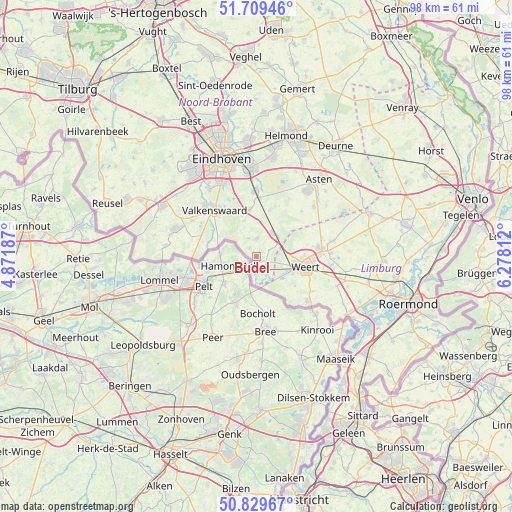
Budel GPS coordinates[2]
51° 16' 18.012" North, 5° 34' 30" East
| Map corner | latitude | longitude |
|---|---|---|
| Upper-left | 51.70946°, | 4.87187° |
| Center: | 51.27167°, | 5.575° |
| Lower-right: | 50.82967°, | 6.27812° |
| Map W x H: | 97.8×97.8 km | = 60.8×60.8mi |
| max Lat: | 53.48025° ⇑90.1% North |
| Budel: | 51.27167° |
| min Lat: | ⇓9.9% South 50.76917° |
| min Long | Budel | max Long |
| 3.38611° | 5.575° | 7.16528° |
| W 46.6%⇐ | ⇒53.4% E |
Elevation
Elevation of Budel is 32 m = 105 ft, and this is 17 m = 56 ft above average elevation for this country.
| Max E: |
203 m = 666 ft | 10.8% |
| Budel | 32 m 105 ft | |
| Avg. | 15 m = 49 ft | |
Min E: |
-6 m = -20 ft | 89.2% |
See also: Netherlands elevation on elevation.city.
Geographical zone
Budel is located in North temperate zone (between Tropic of Cancer and the Arctic Circle). Distance of this North polar circle is 1700.3 km =1056.5 mi to North.| Distance of | km | miles | from Budel |
|---|---|---|---|
| North Pole | 4306.2 | 2675.7 | to North |
| Arctic Circle | 1700.3 | 1056.5 | to North |
| Tropic Cancer | 3095 | 1923.1 | to South |
| Equator | 5700.9 | 3542.4 | to South |


Nearby cities:
15 places around Budel: (largest is in red/bold)
• Altweerterheide
9.2 km =5.7 mi,  127°
127°
• Borkel
9.8 km =6.1 mi,  287°
287°
• Budel-Dorplein
4 km =2.5 mi,  167°
167°
• Budel-Schoot
2.8 km =1.7 mi,  194°
194°
• Cranendonck
3.7 km =2.3 mi,  14°
14°
• Gastel
2.1 km =1.3 mi,  319°
319°
• Keent
9.3 km =5.8 mi,  110°
110°
• Laar
9.1 km =5.7 mi,  87°
87°
• Leende
8.9 km =5.5 mi,  350°
350°
• Leuken
11.3 km =7 mi,  100°
100°
• Maarheeze
5.3 km =3.3 mi,  33°
33°
• Moesel
10.6 km =6.6 mi, 110°
• Soerendonk
3.2 km =2 mi,  0°
0°
• Sterksel
9.2 km =5.7 mi,  15°
15°
• Weert
9.4 km =5.8 mi, 103°
Sources, notices
• [Note1] Compared only with cities in Netherlands existing in our database
• [Src1] Map data: © OpenStreetMap contributors (CC-BY-SA)
• [Src2] Other city data from geonames.org with taken over terms of usage.
• [Src3] Geographical zone / Annual Mean Temperature by Robert A. Rohde @ Wikipedia
