Herwijnen geodata
Herwijnen (Gelderland) is a populated place; located in Netherlands in Europe/Amsterdam (GMT+2) time zone. With population of 2,305 people, there are 889 cities with bigger population in this country. Compared to other cities in Netherlands, 62.7% of cities are located further ↑North; 69.1% of cities are located further →East and 74.9% of cities have higher elevation than Herwijnen. Note1


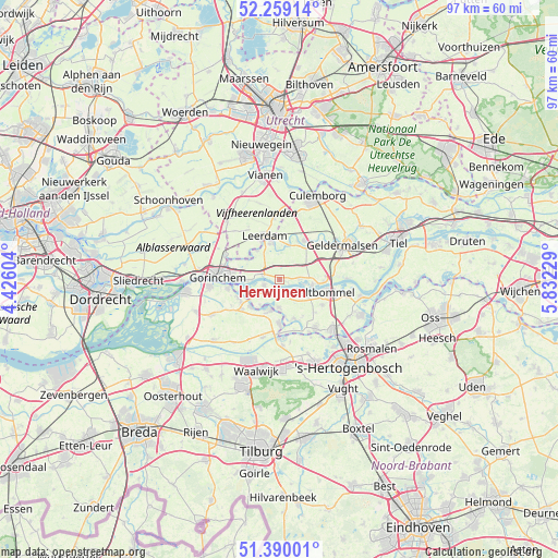
Herwijnen GPS coordinates[2]
51° 49' 36.012" North, 5° 7' 45.012" East
| Map corner | latitude | longitude |
|---|---|---|
| Upper-left | 52.25914°, | 4.42604° |
| Center: | 51.82667°, | 5.12917° |
| Lower-right: | 51.39001°, | 5.83229° |
| Map W x H: | 96.6×96.6 km | = 60×60mi |
| max Lat: | 53.48025° ⇑62.7% North |
| Herwijnen: | 51.82667° |
| min Lat: | ⇓37.3% South 50.76917° |
| min Long | Herwijnen | max Long |
| 3.38611° | 5.12917° | 7.16528° |
| W 30.9%⇐ | ⇒69.1% E |
Elevation
Elevation of Herwijnen is 2 m = 7 ft, and this is 13 m = 43 ft below average elevation for this country.
| Max E: |
203 m = 666 ft | 74.9% |
| Avg. | 15 m = 49 ft | |
| Herwijnen | 2 m = 7 ft | |
Min E: |
-6 m = -20 ft | 25.1% |
See also: Netherlands elevation on elevation.city.
Geographical zone
Herwijnen is located in North temperate zone (between Tropic of Cancer and the Arctic Circle). Distance of this North polar circle is 1638.6 km =1018.2 mi to North.| Distance of | km | miles | from Herwijnen |
|---|---|---|---|
| North Pole | 4244.5 | 2637.4 | to North |
| Arctic Circle | 1638.6 | 1018.2 | to North |
| Tropic Cancer | 3156.7 | 1961.5 | to South |
| Equator | 5762.6 | 3580.7 | to South |


Nearby cities:
15 places around Herwijnen: (largest is in red/bold)
• Aalst
4.9 km =3 mi,  181°
181°
• Andel
6.9 km =4.3 mi,  225°
225°
• Brakel
2.9 km =1.8 mi,  249°
249°
• Gameren
5.9 km =3.7 mi,  119°
119°
• Haaften
5.8 km =3.6 mi,  102°
102°
• Hellouw
3.2 km =2 mi,  90°
90°
• Kedichem
6.6 km =4.1 mi,  304°
304°
• Nieuwaal
3.8 km =2.4 mi, 119°
• Poederoijen
5.6 km =3.5 mi,  216°
216°
• Rhenoy
6.5 km =4 mi,  14°
14°
• Rumpt
7.2 km =4.5 mi,  26°
26°
• Spijk
6.4 km =4 mi,  185°
185°
• Veen
5.7 km =3.5 mi, 194°
• Vuren
5.7 km =3.5 mi,  268°
268°
• Zuilichem
2 km =1.2 mi,  166°
166°
Sources, notices
• [Note1] Compared only with cities in Netherlands existing in our database
• [Src1] Map data: © OpenStreetMap contributors (CC-BY-SA)
• [Src2] Other city data from geonames.org with taken over terms of usage.
• [Src3] Geographical zone / Annual Mean Temperature by Robert A. Rohde @ Wikipedia
