Aldeboarn geodata
Aldeboarn (Friesland) is a populated place; located in Netherlands in Europe/Amsterdam (GMT+2) time zone. With population of 1,525 people, there are 1119 cities with bigger population in this country. Compared to other cities in Netherlands, 87% of cities are located further ↓South; 64.5% of cities are located further ←West and 96.1% of cities have higher elevation than Aldeboarn. Note1


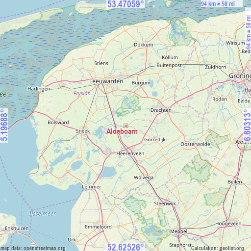
Aldeboarn GPS coordinates[2]
53° 3' 0" North, 5° 54' 0" East
| Map corner | latitude | longitude |
|---|---|---|
| Upper-left | 53.47059°, | 5.19688° |
| Center: | 53.05°, | 5.9° |
| Lower-right: | 52.62526°, | 6.60313° |
| Map W x H: | 94×94 km | = 58.4×58.4mi |
| max Lat: | 53.48025° ⇑13% North |
| Aldeboarn: | 53.05° |
| min Lat: | ⇓87% South 50.76917° |
| min Long | Aldeboarn | max Long |
| 3.38611° | 5.9° | 7.16528° |
| W 64.5%⇐ | ⇒35.5% E |
Elevation
Elevation of Aldeboarn is -1 m = -3 ft, and this is 16 m = 52 ft below average elevation for this country.
| Max E: |
203 m = 666 ft | 96.1% |
| Avg. | 15 m = 49 ft | |
| Aldeboarn | -1 m = -3 ft | |
Min E: |
-6 m = -20 ft | 3.9% |
See also: Netherlands elevation on elevation.city.
Geographical zone
Aldeboarn is located in North temperate zone (between Tropic of Cancer and the Arctic Circle). Distance of this North polar circle is 1502.6 km =933.7 mi to North.| Distance of | km | miles | from Aldeboarn |
|---|---|---|---|
| North Pole | 4108.5 | 2552.9 | to North |
| Arctic Circle | 1502.6 | 933.7 | to North |
| Tropic Cancer | 3292.7 | 2046 | to South |
| Equator | 5898.6 | 3665.2 | to South |


Nearby cities:
15 places around Aldeboarn: (largest is in red/bold)
• Akkrum
4.6 km =2.9 mi,  270°
270°
• Boornbergum
10.4 km =6.5 mi,  69°
69°
• De Knipe
10.3 km =6.4 mi,  152°
152°
• De Wilgen
10.5 km =6.5 mi,  58°
58°
• Grou
6.5 km =4 mi,  319°
319°
• Heerenveen
10.2 km =6.3 mi,  172°
172°
• Jirnsum
7.8 km =4.8 mi,  293°
293°
• Langezwaag
10.2 km =6.3 mi,  137°
137°
• Nes
3.2 km =2 mi, 274°
• Oudega
10.6 km =6.6 mi,  38°
38°
• Oudehaske
10.5 km =6.5 mi,  190°
190°
• Terherne
8 km =5 mi,  256°
256°
• Terwispel
10.4 km =6.5 mi,  108°
108°
• Tijnje
6.5 km =4 mi, 109°
• Tjalleberd
6.6 km =4.1 mi, 153°
Sources, notices
• [Note1] Compared only with cities in Netherlands existing in our database
• [Src1] Map data: © OpenStreetMap contributors (CC-BY-SA)
• [Src2] Other city data from geonames.org with taken over terms of usage.
• [Src3] Geographical zone / Annual Mean Temperature by Robert A. Rohde @ Wikipedia
