Aduard geodata
Aduard (Groningen) is a populated place; located in Netherlands in Europe/Amsterdam (GMT+2) time zone. With population of 2,030 people, there are 951 cities with bigger population in this country. Compared to other cities in Netherlands, 96.1% of cities are located further ↓South; 88.2% of cities are located further ←West and 65.8% of cities have higher elevation than Aduard. Note1


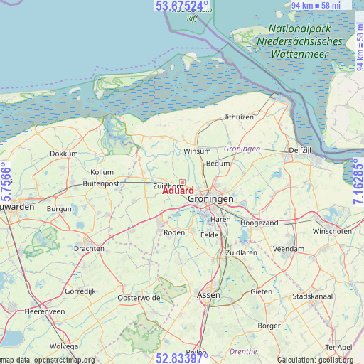
Aduard GPS coordinates[2]
53° 15' 24.012" North, 6° 27' 34.992" East
| Map corner | latitude | longitude |
|---|---|---|
| Upper-left | 53.67524°, | 5.7566° |
| Center: | 53.25667°, | 6.45972° |
| Lower-right: | 52.83397°, | 7.16285° |
| Map W x H: | 93.5×93.5 km | = 58.1×58.1mi |
| max Lat: | 53.48025° ⇑3.9% North |
| Aduard: | 53.25667° |
| min Lat: | ⇓96.1% South 50.76917° |
| min Long | Aduard | max Long |
| 3.38611° | 6.45972° | 7.16528° |
| W 88.2%⇐ | ⇒11.8% E |
Elevation
Elevation of Aduard is 3 m = 10 ft, and this is 12 m = 39 ft below average elevation for this country.
| Max E: |
203 m = 666 ft | 65.8% |
| Avg. | 15 m = 49 ft | |
| Aduard | 3 m = 10 ft | |
Min E: |
-6 m = -20 ft | 34.2% |
See also: Netherlands elevation on elevation.city.
Geographical zone
Aduard is located in North temperate zone (between Tropic of Cancer and the Arctic Circle). Distance of this North polar circle is 1479.6 km =919.4 mi to North.| Distance of | km | miles | from Aduard |
|---|---|---|---|
| North Pole | 4085.5 | 2538.6 | to North |
| Arctic Circle | 1479.6 | 919.4 | to North |
| Tropic Cancer | 3315.7 | 2060.3 | to South |
| Equator | 5921.6 | 3679.5 | to South |


Nearby cities:
15 places around Aduard: (largest is in red/bold)
• Adorp
5.3 km =3.3 mi,  67°
67°
• Ezinge
6 km =3.7 mi,  348°
348°
• Groningen
8.2 km =5.1 mi,  120°
120°
• Korrewegwijk
7.7 km =4.8 mi,  110°
110°
• Niekerk
7.9 km =4.9 mi,  243°
243°
• Noordhorn
4.3 km =2.7 mi,  277°
277°
• Oldehove
6.7 km =4.2 mi,  320°
320°
• Oldekerk
9 km =5.6 mi, 242°
• Reitdiep
4.3 km =2.7 mi, 111°
• Sauwerd
6.4 km =4 mi,  50°
50°
• Selwerd
6.7 km =4.2 mi, 110°
• Van Starkenborgh
7.9 km =4.9 mi,  104°
104°
• Winsum
9.1 km =5.7 mi,  26°
26°
• Zuidhorn
3.9 km =2.4 mi,  253°
253°
• Zuidwolde
8.8 km =5.5 mi,  85°
85°
Sources, notices
• [Note1] Compared only with cities in Netherlands existing in our database
• [Src1] Map data: © OpenStreetMap contributors (CC-BY-SA)
• [Src2] Other city data from geonames.org with taken over terms of usage.
• [Src3] Geographical zone / Annual Mean Temperature by Robert A. Rohde @ Wikipedia
