Gennep geodata
Gennep (Limburg) is a populated place; located in Netherlands in Europe/Amsterdam (GMT+2) time zone. With population of 16,642 people, there are 209 cities with bigger population in this country. Compared to other cities in Netherlands, 68.9% of cities are located further ↑North; 70.3% of cities are located further ←West and 69% of cities have lower elevation than Gennep. Note1


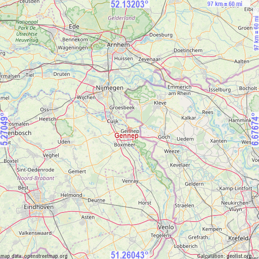
Gennep GPS coordinates[2]
51° 41' 53.988" North, 5° 58' 24.996" East
| Map corner | latitude | longitude |
|---|---|---|
| Upper-left | 52.13203°, | 5.27049° |
| Center: | 51.69833°, | 5.97361° |
| Lower-right: | 51.26043°, | 6.67674° |
| Map W x H: | 96.9×96.9 km | = 60.2×60.2mi |
| max Lat: | 53.48025° ⇑68.9% North |
| Gennep: | 51.69833° |
| min Lat: | ⇓31.1% South 50.76917° |
| min Long | Gennep | max Long |
| 3.38611° | 5.97361° | 7.16528° |
| W 70.3%⇐ | ⇒29.7% E |
Elevation
Elevation of Gennep is 14 m = 46 ft, and this is 1 m = 3 ft below average elevation for this country.
| Max E: |
203 m = 666 ft | 31% |
| Avg. | 15 m = 49 ft | |
| Gennep | 14 m = 46 ft | |
Min E: |
-6 m = -20 ft | 69% |
See also: Netherlands elevation on elevation.city.
Geographical zone
Gennep is located in North temperate zone (between Tropic of Cancer and the Arctic Circle). Distance of this North polar circle is 1652.9 km =1027.1 mi to North.| Distance of | km | miles | from Gennep |
|---|---|---|---|
| North Pole | 4258.7 | 2646.2 | to North |
| Arctic Circle | 1652.9 | 1027.1 | to North |
| Tropic Cancer | 3142.4 | 1952.6 | to South |
| Equator | 5748.3 | 3571.8 | to South |


Nearby cities:
15 places around Gennep: (largest is in red/bold)
• Beers
10.5 km =6.5 mi,  286°
286°
• Boxmeer
6 km =3.7 mi,  197°
197°
• Bredeweg
7.2 km =4.5 mi,  342°
342°
• Cuijk
7.4 km =4.6 mi,  299°
299°
• De Horst
8.4 km =5.2 mi,  357°
357°
• Groesbeek
9.1 km =5.7 mi, 343°
• Haps
7.8 km =4.8 mi,  262°
262°
• Heijen
2.6 km =1.6 mi,  169°
169°
• Milsbeek
3.4 km =2.1 mi,  329°
329°
• Mook
8.7 km =5.4 mi,  313°
313°
• Ottersum
0.9 km =0.6 mi,  50°
50°
• Sint Anthonis
10.2 km =6.3 mi,  218°
218°
• Ven-Zelderheide
3.8 km =2.4 mi,  65°
65°
• Vianen
8.3 km =5.2 mi, 285°
• Wanroij
11.6 km =7.2 mi,  247°
247°
Sources, notices
• [Note1] Compared only with cities in Netherlands existing in our database
• [Src1] Map data: © OpenStreetMap contributors (CC-BY-SA)
• [Src2] Other city data from geonames.org with taken over terms of usage.
• [Src3] Geographical zone / Annual Mean Temperature by Robert A. Rohde @ Wikipedia
