Haps geodata
Haps (North Brabant) is a populated place; located in Netherlands in Europe/Amsterdam (GMT+2) time zone. With population of 2,165 people, there are 921 cities with bigger population in this country. Compared to other cities in Netherlands, 69.5% of cities are located further ↑North; 61.6% of cities are located further ←West and 64.6% of cities have lower elevation than Haps. Note1


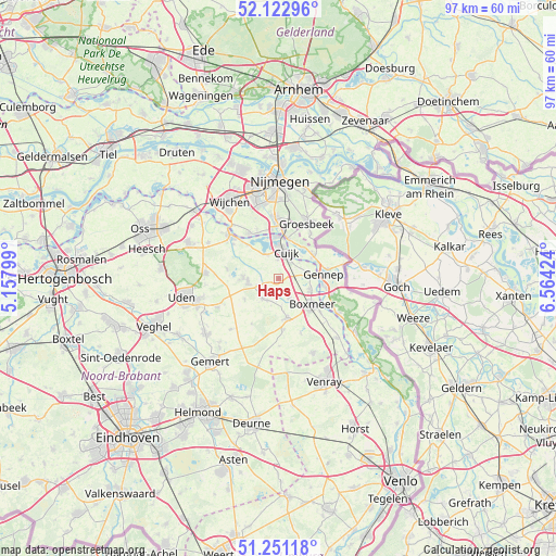
Haps GPS coordinates[2]
51° 41' 21.012" North, 5° 51' 39.996" East
| Map corner | latitude | longitude |
|---|---|---|
| Upper-left | 52.12296°, | 5.15799° |
| Center: | 51.68917°, | 5.86111° |
| Lower-right: | 51.25118°, | 6.56424° |
| Map W x H: | 96.9×96.9 km | = 60.2×60.2mi |
| max Lat: | 53.48025° ⇑69.5% North |
| Haps: | 51.68917° |
| min Lat: | ⇓30.5% South 50.76917° |
| min Long | Haps | max Long |
| 3.38611° | 5.86111° | 7.16528° |
| W 61.6%⇐ | ⇒38.4% E |
Elevation
Elevation of Haps is 12 m = 39 ft, and this is 3 m = 10 ft below average elevation for this country.
| Max E: |
203 m = 666 ft | 35.4% |
| Avg. | 15 m = 49 ft | |
| Haps | 12 m = 39 ft | |
Min E: |
-6 m = -20 ft | 64.6% |
See also: Netherlands elevation on elevation.city.
Geographical zone
Haps is located in North temperate zone (between Tropic of Cancer and the Arctic Circle). Distance of this North polar circle is 1653.9 km =1027.7 mi to North.| Distance of | km | miles | from Haps |
|---|---|---|---|
| North Pole | 4259.8 | 2646.9 | to North |
| Arctic Circle | 1653.9 | 1027.7 | to North |
| Tropic Cancer | 3141.4 | 1952 | to South |
| Equator | 5747.3 | 3571.2 | to South |


Nearby cities:
15 places around Haps: (largest is in red/bold)
• Beers
4.7 km =2.9 mi,  330°
330°
• Boxmeer
7.6 km =4.7 mi,  128°
128°
• Cuijk
4.8 km =3 mi,  15°
15°
• Gennep
7.8 km =4.8 mi,  82°
82°
• Heijen
8.4 km =5.2 mi,  100°
100°
• Heumen
8.5 km =5.3 mi,  352°
352°
• Milsbeek
7.2 km =4.5 mi,  56°
56°
• Mook
7.2 km =4.5 mi,  11°
11°
• Oploo
9 km =5.6 mi,  174°
174°
• Ottersum
8.6 km =5.3 mi, 79°
• Sint Anthonis
7.1 km =4.4 mi, 168°
• Sint Hubert
3.8 km =2.4 mi,  251°
251°
• Vianen
3.3 km =2.1 mi, 354°
• Wanroij
4.6 km =2.9 mi,  220°
220°
• Wilbertoord
7 km =4.3 mi,  238°
238°
Sources, notices
• [Note1] Compared only with cities in Netherlands existing in our database
• [Src1] Map data: © OpenStreetMap contributors (CC-BY-SA)
• [Src2] Other city data from geonames.org with taken over terms of usage.
• [Src3] Geographical zone / Annual Mean Temperature by Robert A. Rohde @ Wikipedia
