Heijen geodata
Heijen (Limburg) is a populated place; located in Netherlands in Europe/Amsterdam (GMT+2) time zone. With population of 1,610 people, there are 1073 cities with bigger population in this country. Compared to other cities in Netherlands, 70.2% of cities are located further ↑North; 71.1% of cities are located further ←West and 73.5% of cities have lower elevation than Heijen. Note1


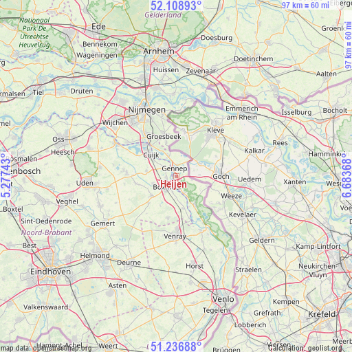
Heijen GPS coordinates[2]
51° 40' 30" North, 5° 58' 50.016" East
| Map corner | latitude | longitude |
|---|---|---|
| Upper-left | 52.10893°, | 5.27743° |
| Center: | 51.675°, | 5.98056° |
| Lower-right: | 51.23688°, | 6.68368° |
| Map W x H: | 97×97 km | = 60.3×60.3mi |
| max Lat: | 53.48025° ⇑70.2% North |
| Heijen: | 51.675° |
| min Lat: | ⇓29.8% South 50.76917° |
| min Long | Heijen | max Long |
| 3.38611° | 5.98056° | 7.16528° |
| W 71.1%⇐ | ⇒28.9% E |
Elevation
Elevation of Heijen is 17 m = 56 ft, and this is 2 m = 7 ft above average elevation for this country.
| Max E: |
203 m = 666 ft | 26.5% |
| Heijen | 17 m 56 ft | |
| Avg. | 15 m = 49 ft | |
Min E: |
-6 m = -20 ft | 73.5% |
See also: Netherlands elevation on elevation.city.
Geographical zone
Heijen is located in North temperate zone (between Tropic of Cancer and the Arctic Circle). Distance of this North polar circle is 1655.5 km =1028.7 mi to North.| Distance of | km | miles | from Heijen |
|---|---|---|---|
| North Pole | 4261.3 | 2647.8 | to North |
| Arctic Circle | 1655.5 | 1028.7 | to North |
| Tropic Cancer | 3139.8 | 1951 | to South |
| Equator | 5745.7 | 3570.2 | to South |


Nearby cities:
15 places around Heijen: (largest is in red/bold)
• Boxmeer
3.9 km =2.4 mi,  216°
216°
• Bredeweg
9.8 km =6.1 mi,  344°
344°
• Cuijk
9.3 km =5.8 mi,  311°
311°
• De Horst
11.1 km =6.9 mi,  355°
355°
• Gennep
2.6 km =1.6 mi,  349°
349°
• Haps
8.4 km =5.2 mi,  280°
280°
• Milsbeek
6 km =3.7 mi, 338°
• Mook
11 km =6.8 mi,  321°
321°
• Oploo
10.5 km =6.5 mi, 224°
• Ottersum
3.2 km =2 mi,  3°
3°
• Overloon
11.7 km =7.3 mi,  191°
191°
• Sint Anthonis
8.7 km =5.4 mi,  231°
231°
• Ven-Zelderheide
5.1 km =3.2 mi,  35°
35°
• Vianen
9.8 km =6.1 mi,  299°
299°
• Wanroij
11.4 km =7.1 mi,  260°
260°
Sources, notices
• [Note1] Compared only with cities in Netherlands existing in our database
• [Src1] Map data: © OpenStreetMap contributors (CC-BY-SA)
• [Src2] Other city data from geonames.org with taken over terms of usage.
• [Src3] Geographical zone / Annual Mean Temperature by Robert A. Rohde @ Wikipedia
