Westerbork geodata
Westerbork (Drenthe) is a populated place; located in Netherlands in Europe/Amsterdam (GMT+2) time zone. With population of 4,605 people, there are 524 cities with bigger population in this country. Compared to other cities in Netherlands, 81.3% of cities are located further ↓South; 91.5% of cities are located further ←West and 73.5% of cities have lower elevation than Westerbork. Note1


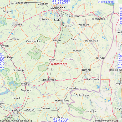
Westerbork GPS coordinates[2]
52° 51' 0" North, 6° 36' 29.988" East
| Map corner | latitude | longitude |
|---|---|---|
| Upper-left | 53.27255°, | 5.90521° |
| Center: | 52.85°, | 6.60833° |
| Lower-right: | 52.4233°, | 7.31146° |
| Map W x H: | 94.4×94.4 km | = 58.7×58.7mi |
| max Lat: | 53.48025° ⇑18.7% North |
| Westerbork: | 52.85° |
| min Lat: | ⇓81.3% South 50.76917° |
| min Long | Westerbork | max Long |
| 3.38611° | 6.60833° | 7.16528° |
| W 91.5%⇐ | ⇒8.5% E |
Elevation
Elevation of Westerbork is 17 m = 56 ft, and this is 2 m = 7 ft above average elevation for this country.
| Max E: |
203 m = 666 ft | 26.5% |
| Westerbork | 17 m 56 ft | |
| Avg. | 15 m = 49 ft | |
Min E: |
-6 m = -20 ft | 73.5% |
See also: Netherlands elevation on elevation.city.
Geographical zone
Westerbork is located in North temperate zone (between Tropic of Cancer and the Arctic Circle). Distance of this North polar circle is 1524.8 km =947.5 mi to North.| Distance of | km | miles | from Westerbork |
|---|---|---|---|
| North Pole | 4130.7 | 2566.7 | to North |
| Arctic Circle | 1524.8 | 947.5 | to North |
| Tropic Cancer | 3270.5 | 2032.2 | to South |
| Equator | 5876.4 | 3651.4 | to South |


Nearby cities:
15 places around Westerbork: (largest is in red/bold)
• Aalden
9.9 km =6.2 mi,  132°
132°
• Beilen
6.5 km =4 mi,  283°
283°
• Borger
14.8 km =9.2 mi,  56°
56°
• Gees
12.6 km =7.8 mi,  154°
154°
• Geesbrug
13.8 km =8.6 mi,  173°
173°
• Grolloo
10.4 km =6.5 mi,  24°
24°
• Hijken
9 km =5.6 mi,  303°
303°
• Hooghalen
9.2 km =5.7 mi,  329°
329°
• Krakeel
15.5 km =9.6 mi,  204°
204°
• Nieuw-Balinge
9.3 km =5.8 mi,  180°
180°
• Oosterhesselen
13.1 km =8.1 mi,  144°
144°
• Rolde
15.2 km =9.4 mi,  10°
10°
• Schoonoord
9.9 km =6.2 mi,  92°
92°
• Sleen
15.7 km =9.8 mi,  123°
123°
• Wijster
7.1 km =4.4 mi,  238°
238°
Sources, notices
• [Note1] Compared only with cities in Netherlands existing in our database
• [Src1] Map data: © OpenStreetMap contributors (CC-BY-SA)
• [Src2] Other city data from geonames.org with taken over terms of usage.
• [Src3] Geographical zone / Annual Mean Temperature by Robert A. Rohde @ Wikipedia
