Oene geodata
Oene (Gelderland) is a populated place; located in Netherlands in Europe/Amsterdam (GMT+2) time zone. With population of 630 people, there are 1686 cities with bigger population in this country. Compared to other cities in Netherlands, 67.8% of cities are located further ↓South; 76% of cities are located further ←West and 50.6% of cities have higher elevation than Oene. Note1


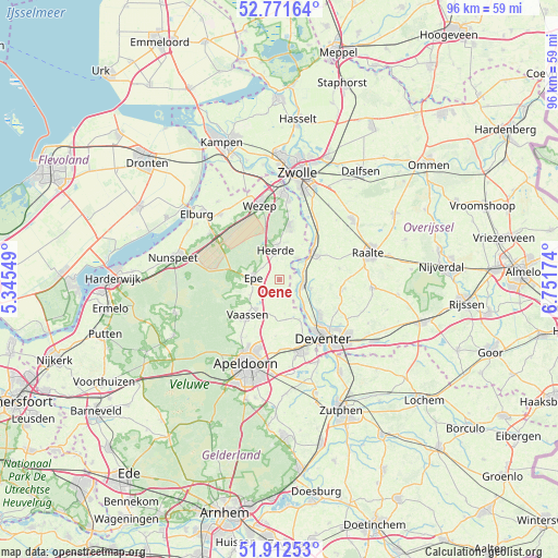
Oene GPS coordinates[2]
52° 20' 39.012" North, 6° 2' 54.996" East
| Map corner | latitude | longitude |
|---|---|---|
| Upper-left | 52.77164°, | 5.34549° |
| Center: | 52.34417°, | 6.04861° |
| Lower-right: | 51.91253°, | 6.75174° |
| Map W x H: | 95.5×95.5 km | = 59.3×59.3mi |
| max Lat: | 53.48025° ⇑32.2% North |
| Oene: | 52.34417° |
| min Lat: | ⇓67.8% South 50.76917° |
| min Long | Oene | max Long |
| 3.38611° | 6.04861° | 7.16528° |
| W 76%⇐ | ⇒24% E |
Elevation
Elevation of Oene is 6 m = 20 ft, and this is 9 m = 30 ft below average elevation for this country.
| Max E: |
203 m = 666 ft | 50.6% |
| Avg. | 15 m = 49 ft | |
| Oene | 6 m = 20 ft | |
Min E: |
-6 m = -20 ft | 49.4% |
See also: Netherlands elevation on elevation.city.
Geographical zone
Oene is located in North temperate zone (between Tropic of Cancer and the Arctic Circle). Distance of this North polar circle is 1581 km =982.4 mi to North.| Distance of | km | miles | from Oene |
|---|---|---|---|
| North Pole | 4186.9 | 2601.6 | to North |
| Arctic Circle | 1581 | 982.4 | to North |
| Tropic Cancer | 3214.2 | 1997.2 | to South |
| Equator | 5820.1 | 3616.4 | to South |


Nearby cities:
15 places around Oene: (largest is in red/bold)
• Beemte-Broekland
10.6 km =6.6 mi,  202°
202°
• Borgele
10.2 km =6.3 mi,  137°
137°
• Boskamp
5.6 km =3.5 mi,  105°
105°
• De Hoven
12.4 km =7.7 mi,  148°
148°
• Elshof
11.6 km =7.2 mi,  61°
61°
• Emst
6 km =3.7 mi,  238°
238°
• Epe
4.4 km =2.7 mi,  274°
274°
• Heerde
4.8 km =3 mi,  353°
353°
• Olst
4.2 km =2.6 mi,  100°
100°
• Terwolde
7.6 km =4.7 mi, 152°
• Twello
12.5 km =7.8 mi,  162°
162°
• Vaassen
8.5 km =5.3 mi,  220°
220°
• Wapenveld
9.6 km =6 mi,  10°
10°
• Welsum
3.1 km =1.9 mi, 107°
• Wijhe
7.5 km =4.7 mi,  51°
51°
Sources, notices
• [Note1] Compared only with cities in Netherlands existing in our database
• [Src1] Map data: © OpenStreetMap contributors (CC-BY-SA)
• [Src2] Other city data from geonames.org with taken over terms of usage.
• [Src3] Geographical zone / Annual Mean Temperature by Robert A. Rohde @ Wikipedia
