Heerde geodata
Heerde (Gelderland) is a populated place; located in Netherlands in Europe/Amsterdam (GMT+2) time zone. With population of 8,850 people, there are 318 cities with bigger population in this country. Compared to other cities in Netherlands, 68.9% of cities are located further ↓South; 75.4% of cities are located further ←West and 55.1% of cities have lower elevation than Heerde. Note1


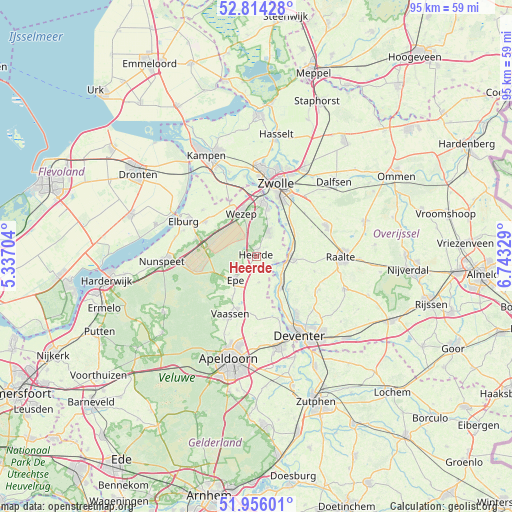
Heerde GPS coordinates[2]
52° 23' 14.028" North, 6° 2' 24.576" East
| Map corner | latitude | longitude |
|---|---|---|
| Upper-left | 52.81428°, | 5.33704° |
| Center: | 52.38723°, | 6.04016° |
| Lower-right: | 51.95601°, | 6.74329° |
| Map W x H: | 95.4×95.4 km | = 59.3×59.3mi |
| max Lat: | 53.48025° ⇑31.1% North |
| Heerde: | 52.38723° |
| min Lat: | ⇓68.9% South 50.76917° |
| min Long | Heerde | max Long |
| 3.38611° | 6.04016° | 7.16528° |
| W 75.4%⇐ | ⇒24.6% E |
Elevation
Elevation of Heerde is 8 m = 26 ft, and this is 7 m = 23 ft below average elevation for this country.
| Max E: |
203 m = 666 ft | 44.9% |
| Avg. | 15 m = 49 ft | |
| Heerde | 8 m = 26 ft | |
Min E: |
-6 m = -20 ft | 55.1% |
See also: Netherlands elevation on elevation.city.
Geographical zone
Heerde is located in North temperate zone (between Tropic of Cancer and the Arctic Circle). Distance of this North polar circle is 1576.3 km =979.5 mi to North.| Distance of | km | miles | from Heerde |
|---|---|---|---|
| North Pole | 4182.1 | 2598.6 | to North |
| Arctic Circle | 1576.3 | 979.5 | to North |
| Tropic Cancer | 3219 | 2000.2 | to South |
| Equator | 5824.9 | 3619.4 | to South |


Nearby cities:
15 places around Heerde: (largest is in red/bold)
• Boskamp
8.6 km =5.3 mi,  136°
136°
• Broekdijk
10.1 km =6.3 mi,  313°
313°
• Elshof
10.9 km =6.8 mi,  86°
86°
• Emst
9.1 km =5.7 mi,  209°
209°
• Epe
5.9 km =3.7 mi,  221°
221°
• Hattem
9.9 km =6.2 mi,  9°
9°
• Hattemerbroek
9.7 km =6 mi,  352°
352°
• Oene
4.8 km =3 mi,  173°
173°
• Oldebroek
11.4 km =7.1 mi,  304°
304°
• Olst
7.3 km =4.5 mi, 139°
• Terwolde
12.2 km =7.6 mi,  160°
160°
• Vaassen
12.3 km =7.6 mi,  203°
203°
• Wapenveld
5.2 km =3.2 mi,  25°
25°
• Welsum
6.7 km =4.2 mi,  148°
148°
• Wijhe
6.4 km =4 mi, 90°
Sources, notices
• [Note1] Compared only with cities in Netherlands existing in our database
• [Src1] Map data: © OpenStreetMap contributors (CC-BY-SA)
• [Src2] Other city data from geonames.org with taken over terms of usage.
• [Src3] Geographical zone / Annual Mean Temperature by Robert A. Rohde @ Wikipedia
