Elshout geodata
Elshout (North Brabant) is a populated place; located in Netherlands in Europe/Amsterdam (GMT+2) time zone. With population of 1,655 people, there are 1058 cities with bigger population in this country. Compared to other cities in Netherlands, 68.8% of cities are located further ↑North; 68.2% of cities are located further →East and 74.9% of cities have higher elevation than Elshout. Note1


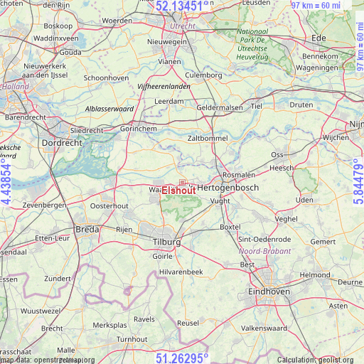
Elshout GPS coordinates[2]
51° 42' 2.988" North, 5° 8' 30.012" East
| Map corner | latitude | longitude |
|---|---|---|
| Upper-left | 52.13451°, | 4.43854° |
| Center: | 51.70083°, | 5.14167° |
| Lower-right: | 51.26295°, | 5.84479° |
| Map W x H: | 96.9×96.9 km | = 60.2×60.2mi |
| max Lat: | 53.48025° ⇑68.8% North |
| Elshout: | 51.70083° |
| min Lat: | ⇓31.2% South 50.76917° |
| min Long | Elshout | max Long |
| 3.38611° | 5.14167° | 7.16528° |
| W 31.8%⇐ | ⇒68.2% E |
Elevation
Elevation of Elshout is 2 m = 7 ft, and this is 13 m = 43 ft below average elevation for this country.
| Max E: |
203 m = 666 ft | 74.9% |
| Avg. | 15 m = 49 ft | |
| Elshout | 2 m = 7 ft | |
Min E: |
-6 m = -20 ft | 25.1% |
See also: Netherlands elevation on elevation.city.
Geographical zone
Elshout is located in North temperate zone (between Tropic of Cancer and the Arctic Circle). Distance of this North polar circle is 1652.6 km =1026.9 mi to North.| Distance of | km | miles | from Elshout |
|---|---|---|---|
| North Pole | 4258.5 | 2646.1 | to North |
| Arctic Circle | 1652.6 | 1026.9 | to North |
| Tropic Cancer | 3142.7 | 1952.8 | to South |
| Equator | 5748.6 | 3572 | to South |


Nearby cities:
15 places around Elshout: (largest is in red/bold)
• Aalburg
6 km =3.7 mi,  353°
353°
• Ammerzoden
7.7 km =4.8 mi,  45°
45°
• Baardwijk
3.3 km =2.1 mi,  253°
253°
• Besoijen
6.6 km =4.1 mi, 252°
• Cromvoirt
7.6 km =4.7 mi,  125°
125°
• Eethen
7.1 km =4.4 mi,  299°
299°
• Genderen
5.4 km =3.4 mi,  316°
316°
• Haarsteeg
4.1 km =2.5 mi,  72°
72°
• Herpt
3.3 km =2.1 mi,  16°
16°
• Heusden
3.7 km =2.3 mi,  357°
357°
• Nederhemert
7.4 km =4.6 mi,  14°
14°
• Nederhemert-Noord
7.3 km =4.5 mi, 17°
• Nieuwkuijk
3 km =1.9 mi,  113°
113°
• Vliedberg
3.6 km =2.2 mi, 110°
• Waalwijk
5.3 km =3.3 mi, 247°
Sources, notices
• [Note1] Compared only with cities in Netherlands existing in our database
• [Src1] Map data: © OpenStreetMap contributors (CC-BY-SA)
• [Src2] Other city data from geonames.org with taken over terms of usage.
• [Src3] Geographical zone / Annual Mean Temperature by Robert A. Rohde @ Wikipedia
