Eibergen geodata
Eibergen (Gelderland) is a populated place; located in Netherlands in Europe/Amsterdam (GMT+2) time zone. With population of 16,493 people, there are 212 cities with bigger population in this country. Compared to other cities in Netherlands, 54.5% of cities are located further ↓South; 92.3% of cities are located further ←West and 84.6% of cities have lower elevation than Eibergen. Note1


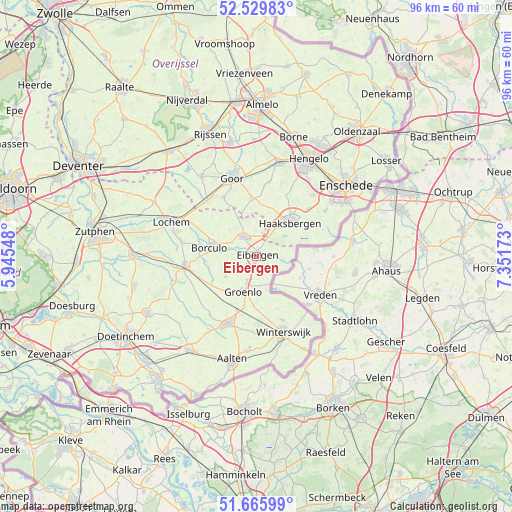
Eibergen GPS coordinates[2]
52° 6' 0" North, 6° 38' 54.996" East
| Map corner | latitude | longitude |
|---|---|---|
| Upper-left | 52.52983°, | 5.94548° |
| Center: | 52.1°, | 6.64861° |
| Lower-right: | 51.66599°, | 7.35173° |
| Map W x H: | 96.1×96 km | = 59.7×59.7mi |
| max Lat: | 53.48025° ⇑45.5% North |
| Eibergen: | 52.1° |
| min Lat: | ⇓54.5% South 50.76917° |
| min Long | Eibergen | max Long |
| 3.38611° | 6.64861° | 7.16528° |
| W 92.3%⇐ | ⇒7.7% E |
Elevation
Elevation of Eibergen is 26 m = 85 ft, and this is 11 m = 36 ft above average elevation for this country.
| Max E: |
203 m = 666 ft | 15.4% |
| Eibergen | 26 m 85 ft | |
| Avg. | 15 m = 49 ft | |
Min E: |
-6 m = -20 ft | 84.6% |
See also: Netherlands elevation on elevation.city.
Geographical zone
Eibergen is located in North temperate zone (between Tropic of Cancer and the Arctic Circle). Distance of this North polar circle is 1608.2 km =999.3 mi to North.| Distance of | km | miles | from Eibergen |
|---|---|---|---|
| North Pole | 4214.1 | 2618.5 | to North |
| Arctic Circle | 1608.2 | 999.3 | to North |
| Tropic Cancer | 3187.1 | 1980.4 | to South |
| Equator | 5793 | 3599.6 | to South |


Nearby cities:
15 places around Eibergen: (largest is in red/bold)
• Barchem
14.3 km =8.9 mi,  280°
280°
• Beltrum
6.9 km =4.3 mi,  237°
237°
• Bentelo
14 km =8.7 mi,  9°
9°
• Borculo
8.8 km =5.5 mi, 281°
• Diepenheim
12.8 km =8 mi,  330°
330°
• Geesteren
9.4 km =5.8 mi,  297°
297°
• Haaksbergen
8.8 km =5.5 mi,  44°
44°
• Hengevelde
11.1 km =6.9 mi,  355°
355°
• Lichtenvoorde
13.8 km =8.6 mi,  203°
203°
• Meddo
10.4 km =6.5 mi,  157°
157°
• Neede
4.5 km =2.8 mi, 328°
• Rietmolen
4.6 km =2.9 mi, 11°
• Ruurlo
13.6 km =8.5 mi,  264°
264°
• Wiene
15 km =9.3 mi,  0°
0°
• Winterswijk
15 km =9.3 mi, 161°
Sources, notices
• [Note1] Compared only with cities in Netherlands existing in our database
• [Src1] Map data: © OpenStreetMap contributors (CC-BY-SA)
• [Src2] Other city data from geonames.org with taken over terms of usage.
• [Src3] Geographical zone / Annual Mean Temperature by Robert A. Rohde @ Wikipedia
