Ruurlo geodata
Ruurlo (Gelderland) is a populated place; located in Netherlands in Europe/Amsterdam (GMT+2) time zone. With population of 5,940 people, there are 414 cities with bigger population in this country. Compared to other cities in Netherlands, 54.2% of cities are located further ↓South; 88% of cities are located further ←West and 74.9% of cities have lower elevation than Ruurlo. Note1


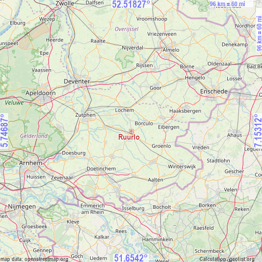
Ruurlo GPS coordinates[2]
52° 5' 17.988" North, 6° 27' 0" East
| Map corner | latitude | longitude |
|---|---|---|
| Upper-left | 52.51827°, | 5.74687° |
| Center: | 52.08833°, | 6.45° |
| Lower-right: | 51.6542°, | 7.15312° |
| Map W x H: | 96.1×96.1 km | = 59.7×59.7mi |
| max Lat: | 53.48025° ⇑45.8% North |
| Ruurlo: | 52.08833° |
| min Lat: | ⇓54.2% South 50.76917° |
| min Long | Ruurlo | max Long |
| 3.38611° | 6.45° | 7.16528° |
| W 88%⇐ | ⇒12% E |
Elevation
Elevation of Ruurlo is 18 m = 59 ft, and this is 3 m = 10 ft above average elevation for this country.
| Max E: |
203 m = 666 ft | 25.1% |
| Ruurlo | 18 m 59 ft | |
| Avg. | 15 m = 49 ft | |
Min E: |
-6 m = -20 ft | 74.9% |
See also: Netherlands elevation on elevation.city.
Geographical zone
Ruurlo is located in North temperate zone (between Tropic of Cancer and the Arctic Circle). Distance of this North polar circle is 1609.5 km =1000.1 mi to North.| Distance of | km | miles | from Ruurlo |
|---|---|---|---|
| North Pole | 4215.4 | 2619.3 | to North |
| Arctic Circle | 1609.5 | 1000.1 | to North |
| Tropic Cancer | 3185.8 | 1979.6 | to South |
| Equator | 5791.7 | 3598.8 | to South |


Nearby cities:
15 places around Ruurlo: (largest is in red/bold)
• Almen
12.9 km =8 mi,  307°
307°
• Barchem
4 km =2.5 mi,  353°
353°
• Beltrum
8.1 km =5 mi,  107°
107°
• Borculo
5.8 km =3.6 mi,  58°
58°
• Eibergen
13.6 km =8.5 mi,  84°
84°
• Geesteren
7.7 km =4.8 mi,  42°
42°
• Halle
11.1 km =6.9 mi,  187°
187°
• Hengelo
10.5 km =6.5 mi,  246°
246°
• Keijenborg
12.5 km =7.8 mi,  238°
238°
• Laren
13.1 km =8.1 mi,  333°
333°
• Lochem
8.3 km =5.2 mi,  341°
341°
• Neede
12.3 km =7.6 mi,  65°
65°
• Vorden
9.8 km =6.1 mi,  280°
280°
• Warken
13.7 km =8.5 mi,  294°
294°
• Zelhem
11.4 km =7.1 mi,  217°
217°
Sources, notices
• [Note1] Compared only with cities in Netherlands existing in our database
• [Src1] Map data: © OpenStreetMap contributors (CC-BY-SA)
• [Src2] Other city data from geonames.org with taken over terms of usage.
• [Src3] Geographical zone / Annual Mean Temperature by Robert A. Rohde @ Wikipedia
