Beltrum geodata
Beltrum (Gelderland) is a populated place; located in Netherlands in Europe/Amsterdam (GMT+2) time zone. With population of 1,285 people, there are 1247 cities with bigger population in this country. Compared to other cities in Netherlands, 52.7% of cities are located further ↓South; 90.3% of cities are located further ←West and 77.1% of cities have lower elevation than Beltrum. Note1


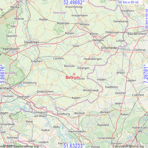
Beltrum GPS coordinates[2]
52° 4' 0.012" North, 6° 33' 50.004" East
| Map corner | latitude | longitude |
|---|---|---|
| Upper-left | 52.49682°, | 5.86076° |
| Center: | 52.06667°, | 6.56389° |
| Lower-right: | 51.63233°, | 7.26701° |
| Map W x H: | 96.1×96.1 km | = 59.7×59.7mi |
| max Lat: | 53.48025° ⇑47.3% North |
| Beltrum: | 52.06667° |
| min Lat: | ⇓52.7% South 50.76917° |
| min Long | Beltrum | max Long |
| 3.38611° | 6.56389° | 7.16528° |
| W 90.3%⇐ | ⇒9.7% E |
Elevation
Elevation of Beltrum is 19 m = 62 ft, and this is 4 m = 13 ft above average elevation for this country.
| Max E: |
203 m = 666 ft | 22.9% |
| Beltrum | 19 m 62 ft | |
| Avg. | 15 m = 49 ft | |
Min E: |
-6 m = -20 ft | 77.1% |
See also: Netherlands elevation on elevation.city.
Geographical zone
Beltrum is located in North temperate zone (between Tropic of Cancer and the Arctic Circle). Distance of this North polar circle is 1611.9 km =1001.6 mi to North.| Distance of | km | miles | from Beltrum |
|---|---|---|---|
| North Pole | 4217.8 | 2620.8 | to North |
| Arctic Circle | 1611.9 | 1001.6 | to North |
| Tropic Cancer | 3183.4 | 1978.1 | to South |
| Equator | 5789.3 | 3597.3 | to South |


Nearby cities:
15 places around Beltrum: (largest is in red/bold)
• Barchem
10.4 km =6.5 mi,  307°
307°
• Borculo
6.2 km =3.9 mi,  332°
332°
• Bredevoort
14.4 km =8.9 mi,  164°
164°
• Diepenheim
14.8 km =9.2 mi,  357°
357°
• Eibergen
6.9 km =4.3 mi,  57°
57°
• Geesteren
8.5 km =5.3 mi,  342°
342°
• Halle
12.6 km =7.8 mi,  226°
226°
• Hengevelde
15.5 km =9.6 mi,  18°
18°
• Lichtenvoorde
8.9 km =5.5 mi,  178°
178°
• Lochem
14.6 km =9.1 mi, 314°
• Meddo
11.4 km =7.1 mi,  121°
121°
• Neede
8.2 km =5.1 mi, 24°
• Rietmolen
10.6 km =6.6 mi,  39°
39°
• Ruurlo
8.1 km =5 mi,  287°
287°
• Winterswijk
14.9 km =9.3 mi,  134°
134°
Sources, notices
• [Note1] Compared only with cities in Netherlands existing in our database
• [Src1] Map data: © OpenStreetMap contributors (CC-BY-SA)
• [Src2] Other city data from geonames.org with taken over terms of usage.
• [Src3] Geographical zone / Annual Mean Temperature by Robert A. Rohde @ Wikipedia
