Borkel geodata
Borkel (North Brabant) is a populated place; located in Netherlands in Europe/Amsterdam (GMT+2) time zone. With population of 595 people, there are 1725 cities with bigger population in this country. Compared to other cities in Netherlands, 89.4% of cities are located further ↑North; 59.1% of cities are located further →East and 89.2% of cities have lower elevation than Borkel. Note1


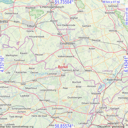
Borkel GPS coordinates[2]
51° 17' 51" North, 5° 26' 25.008" East
| Map corner | latitude | longitude |
|---|---|---|
| Upper-left | 51.73504°, | 4.73716° |
| Center: | 51.2975°, | 5.44028° |
| Lower-right: | 50.85574°, | 6.14341° |
| Map W x H: | 97.8×97.8 km | = 60.8×60.8mi |
| max Lat: | 53.48025° ⇑89.4% North |
| Borkel: | 51.2975° |
| min Lat: | ⇓10.6% South 50.76917° |
| min Long | Borkel | max Long |
| 3.38611° | 5.44028° | 7.16528° |
| W 40.9%⇐ | ⇒59.1% E |
Elevation
Elevation of Borkel is 32 m = 105 ft, and this is 17 m = 56 ft above average elevation for this country.
| Max E: |
203 m = 666 ft | 10.8% |
| Borkel | 32 m 105 ft | |
| Avg. | 15 m = 49 ft | |
Min E: |
-6 m = -20 ft | 89.2% |
See also: Netherlands elevation on elevation.city.
Geographical zone
Borkel is located in North temperate zone (between Tropic of Cancer and the Arctic Circle). Distance of this North polar circle is 1697.4 km =1054.7 mi to North.| Distance of | km | miles | from Borkel |
|---|---|---|---|
| North Pole | 4303.3 | 2673.9 | to North |
| Arctic Circle | 1697.4 | 1054.7 | to North |
| Tropic Cancer | 3097.8 | 1924.9 | to South |
| Equator | 5703.7 | 3544.1 | to South |


Nearby cities:
15 places around Borkel: (largest is in red/bold)
• Bergeijk
6.2 km =3.9 mi,  292°
292°
• Budel
9.8 km =6.1 mi,  107°
107°
• Budel-Schoot
10.3 km =6.4 mi,  122°
122°
• Cranendonck
10.4 km =6.5 mi,  85°
85°
• Dommelen
5.4 km =3.4 mi,  355°
355°
• Gastel
8.1 km =5 mi,  99°
99°
• Geenhoven
7 km =4.3 mi,  11°
11°
• Leende
9.9 km =6.2 mi,  53°
53°
• Luyksgestel
8.2 km =5.1 mi,  263°
263°
• Riethoven
7.3 km =4.5 mi,  329°
329°
• Soerendonk
9.4 km =5.8 mi, 87°
• Valkenswaard
6.1 km =3.8 mi, 12°
• Waalre
9.9 km =6.2 mi,  1°
1°
• Weebosch
10.2 km =6.3 mi,  276°
276°
• Westerhoven
5 km =3.1 mi,  321°
321°
Sources, notices
• [Note1] Compared only with cities in Netherlands existing in our database
• [Src1] Map data: © OpenStreetMap contributors (CC-BY-SA)
• [Src2] Other city data from geonames.org with taken over terms of usage.
• [Src3] Geographical zone / Annual Mean Temperature by Robert A. Rohde @ Wikipedia
