Boornbergum geodata
Boornbergum (Friesland) is a populated place; located in Netherlands in Europe/Amsterdam (GMT+2) time zone. With population of 1,660 people, there are 1055 cities with bigger population in this country. Compared to other cities in Netherlands, 88.4% of cities are located further ↓South; 75.6% of cities are located further ←West and 74.9% of cities have higher elevation than Boornbergum. Note1


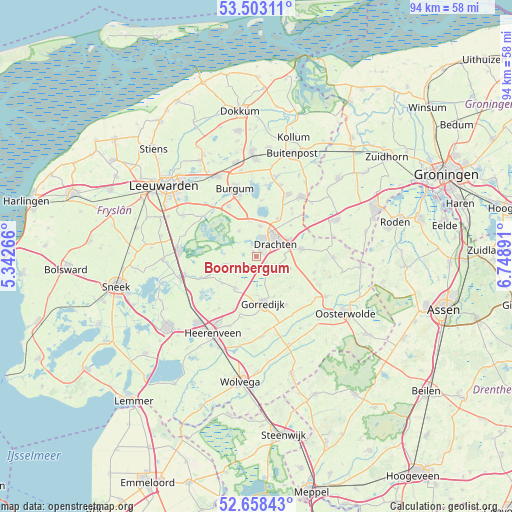
Boornbergum GPS coordinates[2]
53° 4' 58.224" North, 6° 2' 44.808" East
| Map corner | latitude | longitude |
|---|---|---|
| Upper-left | 53.50311°, | 5.34266° |
| Center: | 53.08284°, | 6.04578° |
| Lower-right: | 52.65843°, | 6.74891° |
| Map W x H: | 93.9×93.9 km | = 58.3×58.3mi |
| max Lat: | 53.48025° ⇑11.6% North |
| Boornbergum: | 53.08284° |
| min Lat: | ⇓88.4% South 50.76917° |
| min Long | Boornbergum | max Long |
| 3.38611° | 6.04578° | 7.16528° |
| W 75.6%⇐ | ⇒24.4% E |
Elevation
Elevation of Boornbergum is 2 m = 7 ft, and this is 13 m = 43 ft below average elevation for this country.
| Max E: |
203 m = 666 ft | 74.9% |
| Avg. | 15 m = 49 ft | |
| Boornbergum | 2 m = 7 ft | |
Min E: |
-6 m = -20 ft | 25.1% |
See also: Netherlands elevation on elevation.city.
Geographical zone
Boornbergum is located in North temperate zone (between Tropic of Cancer and the Arctic Circle). Distance of this North polar circle is 1498.9 km =931.4 mi to North.| Distance of | km | miles | from Boornbergum |
|---|---|---|---|
| North Pole | 4104.8 | 2550.6 | to North |
| Arctic Circle | 1498.9 | 931.4 | to North |
| Tropic Cancer | 3296.3 | 2048.2 | to South |
| Equator | 5902.3 | 3667.5 | to South |


Nearby cities:
15 places around Boornbergum: (largest is in red/bold)
• Beetsterzwaag
3.4 km =2.1 mi,  141°
141°
• De Drait
2.2 km =1.4 mi,  42°
42°
• De Wilgen
2 km =1.2 mi,  336°
336°
• Drachten
4.8 km =3 mi,  47°
47°
• Drachtstercompagnie
8.6 km =5.3 mi, 47°
• Gorredijk
8.6 km =5.3 mi,  171°
171°
• Houtigehage
10.2 km =6.3 mi, 40°
• Jubbega
10.1 km =6.3 mi,  149°
149°
• Lippenhuizen
7.8 km =4.8 mi,  156°
156°
• Opeinde
5.7 km =3.5 mi,  7°
7°
• Oudega
5.6 km =3.5 mi,  326°
326°
• Rottevalle
8 km =5 mi,  29°
29°
• Terwispel
7 km =4.3 mi,  178°
178°
• Tijnje
6.8 km =4.2 mi,  211°
211°
• Ureterp
8.2 km =5.1 mi,  82°
82°
Sources, notices
• [Note1] Compared only with cities in Netherlands existing in our database
• [Src1] Map data: © OpenStreetMap contributors (CC-BY-SA)
• [Src2] Other city data from geonames.org with taken over terms of usage.
• [Src3] Geographical zone / Annual Mean Temperature by Robert A. Rohde @ Wikipedia
