Witmarsum geodata
Witmarsum (Friesland) is a populated place; located in Netherlands in Europe/Amsterdam (GMT+2) time zone. With population of 1,585 people, there are 1092 cities with bigger population in this country. Compared to other cities in Netherlands, 89.1% of cities are located further ↓South; 57.9% of cities are located further →East and 83.9% of cities have higher elevation than Witmarsum. Note1


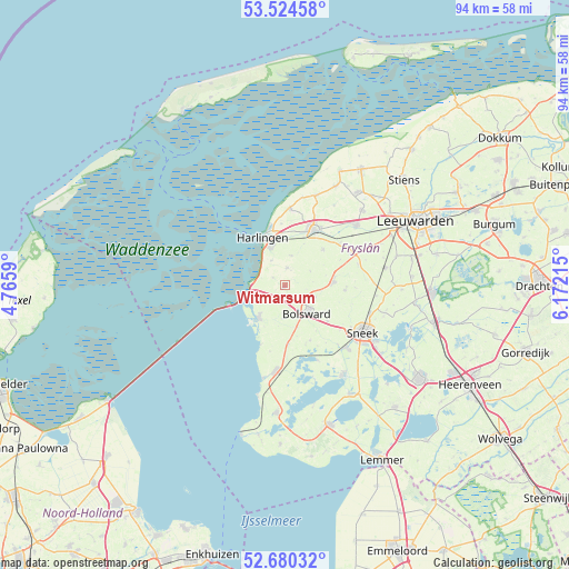
Witmarsum GPS coordinates[2]
53° 6' 16.272" North, 5° 28' 8.472" East
| Map corner | latitude | longitude |
|---|---|---|
| Upper-left | 53.52458°, | 4.7659° |
| Center: | 53.10452°, | 5.46902° |
| Lower-right: | 52.68032°, | 6.17215° |
| Map W x H: | 93.9×93.9 km | = 58.3×58.3mi |
| max Lat: | 53.48025° ⇑10.9% North |
| Witmarsum: | 53.10452° |
| min Lat: | ⇓89.1% South 50.76917° |
| min Long | Witmarsum | max Long |
| 3.38611° | 5.46902° | 7.16528° |
| W 42.1%⇐ | ⇒57.9% E |
Elevation
Elevation of Witmarsum is 1 m = 3 ft, and this is 14 m = 46 ft below average elevation for this country.
| Max E: |
203 m = 666 ft | 83.9% |
| Avg. | 15 m = 49 ft | |
| Witmarsum | 1 m = 3 ft | |
Min E: |
-6 m = -20 ft | 16.1% |
See also: Netherlands elevation on elevation.city.
Geographical zone
Witmarsum is located in North temperate zone (between Tropic of Cancer and the Arctic Circle). Distance of this North polar circle is 1496.5 km =929.9 mi to North.| Distance of | km | miles | from Witmarsum |
|---|---|---|---|
| North Pole | 4102.4 | 2549.1 | to North |
| Arctic Circle | 1496.5 | 929.9 | to North |
| Tropic Cancer | 3298.8 | 2049.8 | to South |
| Equator | 5904.7 | 3669 | to South |


Nearby cities:
15 places around Witmarsum: (largest is in red/bold)
• Achlum
5.1 km =3.2 mi,  10°
10°
• Arum
2.8 km =1.7 mi, 10°
• Blauwhuis
10.2 km =6.3 mi,  154°
154°
• Bolsward
6 km =3.7 mi,  135°
135°
• Franeker
10.2 km =6.3 mi,  28°
28°
• Harlingen
8.4 km =5.2 mi,  338°
338°
• Makkum
7.1 km =4.4 mi,  218°
218°
• Midlum
8.7 km =5.4 mi,  350°
350°
• Nijland
9.4 km =5.8 mi,  130°
130°
• Oudega
13.6 km =8.5 mi,  156°
156°
• Sexbierum
12.7 km =7.9 mi,  4°
4°
• Tzum
8.7 km =5.4 mi,  45°
45°
• Winsum
12.2 km =7.6 mi,  64°
64°
• Wommels
7.9 km =4.9 mi,  86°
86°
• Ysbrechtum
13 km =8.1 mi,  122°
122°
Sources, notices
• [Note1] Compared only with cities in Netherlands existing in our database
• [Src1] Map data: © OpenStreetMap contributors (CC-BY-SA)
• [Src2] Other city data from geonames.org with taken over terms of usage.
• [Src3] Geographical zone / Annual Mean Temperature by Robert A. Rohde @ Wikipedia
