Breukelen geodata
Breukelen (Utrecht) is a populated place; located in Netherlands in Europe/Amsterdam (GMT+2) time zone. With population of 14,498 people, there are 227 cities with bigger population in this country. Compared to other cities in Netherlands, 58.4% of cities are located further ↓South; 73.5% of cities are located further →East and 74.9% of cities have higher elevation than Breukelen. Note1


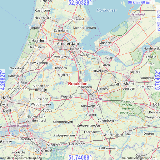
Breukelen GPS coordinates[2]
52° 10' 27.012" North, 5° 0' 5.004" East
| Map corner | latitude | longitude |
|---|---|---|
| Upper-left | 52.60328°, | 4.29827° |
| Center: | 52.17417°, | 5.00139° |
| Lower-right: | 51.74088°, | 5.70452° |
| Map W x H: | 95.9×95.9 km | = 59.6×59.6mi |
| max Lat: | 53.48025° ⇑41.6% North |
| Breukelen: | 52.17417° |
| min Lat: | ⇓58.4% South 50.76917° |
| min Long | Breukelen | max Long |
| 3.38611° | 5.00139° | 7.16528° |
| W 26.5%⇐ | ⇒73.5% E |
Elevation
Elevation of Breukelen is 2 m = 7 ft, and this is 13 m = 43 ft below average elevation for this country.
| Max E: |
203 m = 666 ft | 74.9% |
| Avg. | 15 m = 49 ft | |
| Breukelen | 2 m = 7 ft | |
Min E: |
-6 m = -20 ft | 25.1% |
See also: Netherlands elevation on elevation.city.
Geographical zone
Breukelen is located in North temperate zone (between Tropic of Cancer and the Arctic Circle). Distance of this North polar circle is 1600 km =994.2 mi to North.| Distance of | km | miles | from Breukelen |
|---|---|---|---|
| North Pole | 4205.8 | 2613.4 | to North |
| Arctic Circle | 1600 | 994.2 | to North |
| Tropic Cancer | 3195.3 | 1985.5 | to South |
| Equator | 5801.2 | 3604.7 | to South |


Nearby cities:
15 places around Breukelen: (largest is in red/bold)
• Baambrugge
8 km =5 mi,  353°
353°
• Horstermeer
9.9 km =6.2 mi,  31°
31°
• Kerkelanden
10.3 km =6.4 mi,  62°
62°
• Kortenhoef
10.2 km =6.3 mi,  44°
44°
• Maarssen
4.8 km =3 mi,  144°
144°
• Maarsseveen
6.1 km =3.8 mi,  126°
126°
• Mijdrecht
10.1 km =6.3 mi,  290°
290°
• Nieuw-Loosdrecht
9.8 km =6.1 mi,  73°
73°
• Oud-Loosdrecht
6.5 km =4 mi, 56°
• Oud-Zuilen
6.9 km =4.3 mi, 138°
• Spechtenkamp
4 km =2.5 mi,  164°
164°
• Vinkeveen
6.5 km =4 mi,  314°
314°
• Vleuten
7.7 km =4.8 mi,  172°
172°
• Wilnis
7.5 km =4.7 mi, 289°
• Woerdense Verlaat
9.6 km =6 mi,  257°
257°
Sources, notices
• [Note1] Compared only with cities in Netherlands existing in our database
• [Src1] Map data: © OpenStreetMap contributors (CC-BY-SA)
• [Src2] Other city data from geonames.org with taken over terms of usage.
• [Src3] Geographical zone / Annual Mean Temperature by Robert A. Rohde @ Wikipedia
