Almelo geodata
Almelo (Overijssel) is a populated place; located in Netherlands in Europe/Amsterdam (GMT+2) time zone. With population of 72,725 people, there are 40 cities with bigger population in this country. Compared to other cities in Netherlands, 68.2% of cities are located further ↓South; 92.7% of cities are located further ←West and 70.6% of cities have lower elevation than Almelo. Note1


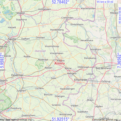
Almelo GPS coordinates[2]
52° 21' 24.012" North, 6° 39' 45" East
| Map corner | latitude | longitude |
|---|---|---|
| Upper-left | 52.78402°, | 5.95937° |
| Center: | 52.35667°, | 6.6625° |
| Lower-right: | 51.92515°, | 7.36562° |
| Map W x H: | 95.5×95.5 km | = 59.3×59.3mi |
| max Lat: | 53.48025° ⇑31.8% North |
| Almelo: | 52.35667° |
| min Lat: | ⇓68.2% South 50.76917° |
| min Long | Almelo | max Long |
| 3.38611° | 6.6625° | 7.16528° |
| W 92.7%⇐ | ⇒7.3% E |
Elevation
Elevation of Almelo is 15 m = 49 ft, and this is 0 m = 0 ft above average elevation for this country.
| Max E: |
203 m = 666 ft | 29.4% |
| Almelo | 15 m 49 ft | |
| Avg. | 15 m = 49 ft | |
Min E: |
-6 m = -20 ft | 70.6% |
See also: Almelo elevation on elevation.city.
Geographical zone
Almelo is located in North temperate zone (between Tropic of Cancer and the Arctic Circle). Distance of this North polar circle is 1579.7 km =981.6 mi to North.| Distance of | km | miles | from Almelo |
|---|---|---|---|
| North Pole | 4185.5 | 2600.7 | to North |
| Arctic Circle | 1579.7 | 981.6 | to North |
| Tropic Cancer | 3215.6 | 1998.1 | to South |
| Equator | 5821.5 | 3617.3 | to South |


Nearby cities:
15 places around Almelo: (largest is in red/bold)
• Borne
8.5 km =5.3 mi,  136°
136°
• Bornerbroek
5.3 km =3.3 mi,  186°
186°
• Daarle
12.1 km =7.5 mi,  315°
315°
• Delden
11.2 km =7 mi,  162°
162°
• Elsen
12.8 km =8 mi,  221°
221°
• Hulsen
13.1 km =8.1 mi,  281°
281°
• Nijrees
2.4 km =1.5 mi,  177°
177°
• Saasveld
10.2 km =6.3 mi,  105°
105°
• Tubbergen
10 km =6.2 mi,  55°
55°
• Vriezenveen
6.4 km =4 mi,  334°
334°
• Westerhaar-Vriezenveensewijk
11.3 km =7 mi,  346°
346°
• Wierden
4.7 km =2.9 mi,  273°
273°
• Woolde
11.5 km =7.1 mi,  145°
145°
• Zeldam
11.3 km =7 mi, 191°
• Zenderen
5.5 km =3.4 mi,  131°
131°
Sources, notices
• [Note1] Compared only with cities in Netherlands existing in our database
• [Src1] Map data: © OpenStreetMap contributors (CC-BY-SA)
• [Src2] Other city data from geonames.org with taken over terms of usage.
• [Src3] Geographical zone / Annual Mean Temperature by Robert A. Rohde @ Wikipedia
