Vriezenveen geodata
Vriezenveen (Overijssel) is a populated place; located in Netherlands in Europe/Amsterdam (GMT+2) time zone. With population of 12,310 people, there are 250 cities with bigger population in this country. Compared to other cities in Netherlands, 69.3% of cities are located further ↓South; 91.8% of cities are located further ←West and 59.4% of cities have lower elevation than Vriezenveen. Note1


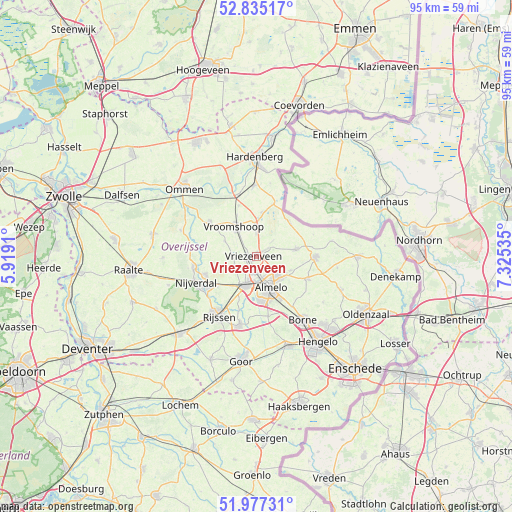
Vriezenveen GPS coordinates[2]
52° 24' 29.988" North, 6° 37' 19.992" East
| Map corner | latitude | longitude |
|---|---|---|
| Upper-left | 52.83517°, | 5.9191° |
| Center: | 52.40833°, | 6.62222° |
| Lower-right: | 51.97731°, | 7.32535° |
| Map W x H: | 95.4×95.4 km | = 59.3×59.3mi |
| max Lat: | 53.48025° ⇑30.7% North |
| Vriezenveen: | 52.40833° |
| min Lat: | ⇓69.3% South 50.76917° |
| min Long | Vriezenveen | max Long |
| 3.38611° | 6.62222° | 7.16528° |
| W 91.8%⇐ | ⇒8.2% E |
Elevation
Elevation of Vriezenveen is 10 m = 33 ft, and this is 5 m = 16 ft below average elevation for this country.
| Max E: |
203 m = 666 ft | 40.6% |
| Avg. | 15 m = 49 ft | |
| Vriezenveen | 10 m = 33 ft | |
Min E: |
-6 m = -20 ft | 59.4% |
See also: Netherlands elevation on elevation.city.
Geographical zone
Vriezenveen is located in North temperate zone (between Tropic of Cancer and the Arctic Circle). Distance of this North polar circle is 1573.9 km =978 mi to North.| Distance of | km | miles | from Vriezenveen |
|---|---|---|---|
| North Pole | 4179.8 | 2597.2 | to North |
| Arctic Circle | 1573.9 | 978 | to North |
| Tropic Cancer | 3221.3 | 2001.6 | to South |
| Equator | 5827.3 | 3620.9 | to South |


Nearby cities:
15 places around Vriezenveen: (largest is in red/bold)
• Almelo
6.4 km =4 mi,  154°
154°
• Bornerbroek
11.2 km =7 mi,  168°
168°
• Daarle
6.4 km =4 mi,  296°
296°
• Den Ham
10.7 km =6.6 mi,  306°
306°
• Hellendoorn
11.8 km =7.3 mi,  259°
259°
• Hulsen
10.6 km =6.6 mi,  252°
252°
• Magele
9.6 km =6 mi, 314°
• Marle
9.8 km =6.1 mi,  280°
280°
• Nieuwoord
8.1 km =5 mi,  322°
322°
• Nijrees
8.6 km =5.3 mi,  160°
160°
• Tubbergen
11 km =6.8 mi,  90°
90°
• Vroomshoop
7 km =4.3 mi,  326°
326°
• Westerhaar-Vriezenveensewijk
5.3 km =3.3 mi,  1°
1°
• Wierden
5.8 km =3.6 mi,  199°
199°
• Zenderen
11.6 km =7.2 mi,  143°
143°
Sources, notices
• [Note1] Compared only with cities in Netherlands existing in our database
• [Src1] Map data: © OpenStreetMap contributors (CC-BY-SA)
• [Src2] Other city data from geonames.org with taken over terms of usage.
• [Src3] Geographical zone / Annual Mean Temperature by Robert A. Rohde @ Wikipedia
