Middenmeer geodata
Middenmeer (North Holland) is a populated place; located in Netherlands in Europe/Amsterdam (GMT+2) time zone. With population of 3,155 people, there are 735 cities with bigger population in this country. Compared to other cities in Netherlands, 80.1% of cities are located further ↓South; 73.5% of cities are located further →East and 99.2% of cities have higher elevation than Middenmeer. Note1


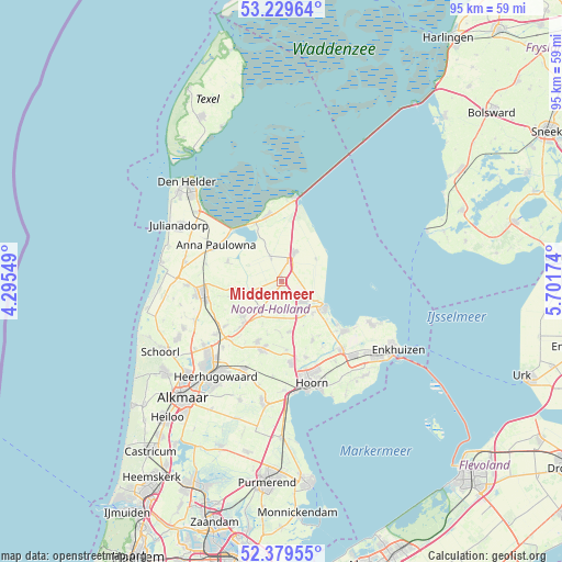
Middenmeer GPS coordinates[2]
52° 48' 24.012" North, 4° 59' 54.996" East
| Map corner | latitude | longitude |
|---|---|---|
| Upper-left | 53.22964°, | 4.29549° |
| Center: | 52.80667°, | 4.99861° |
| Lower-right: | 52.37955°, | 5.70174° |
| Map W x H: | 94.5×94.5 km | = 58.7×58.7mi |
| max Lat: | 53.48025° ⇑19.9% North |
| Middenmeer: | 52.80667° |
| min Lat: | ⇓80.1% South 50.76917° |
| min Long | Middenmeer | max Long |
| 3.38611° | 4.99861° | 7.16528° |
| W 26.5%⇐ | ⇒73.5% E |
Elevation
Elevation of Middenmeer is -3 m = -10 ft, and this is 18 m = 59 ft below average elevation for this country.
| Max E: |
203 m = 666 ft | 99.2% |
| Avg. | 15 m = 49 ft | |
| Middenmeer | -3 m = -10 ft | |
Min E: |
-6 m = -20 ft | 0.8% |
See also: Netherlands elevation on elevation.city.
Geographical zone
Middenmeer is located in North temperate zone (between Tropic of Cancer and the Arctic Circle). Distance of this North polar circle is 1529.6 km =950.4 mi to North.| Distance of | km | miles | from Middenmeer |
|---|---|---|---|
| North Pole | 4135.5 | 2569.7 | to North |
| Arctic Circle | 1529.6 | 950.4 | to North |
| Tropic Cancer | 3265.6 | 2029.1 | to South |
| Equator | 5871.6 | 3648.4 | to South |


Nearby cities:
15 places around Middenmeer: (largest is in red/bold)
• Abbekerk
8.4 km =5.2 mi,  171°
171°
• Barsingerhorn
9.4 km =5.8 mi,  255°
255°
• De Weere
8.9 km =5.5 mi,  181°
181°
• Kolhorn
7.5 km =4.7 mi, 259°
• Kreileroord
6.8 km =4.2 mi,  55°
55°
• Medemblik
8.2 km =5.1 mi,  118°
118°
• Nieuwe-Niedorp
10 km =6.2 mi,  222°
222°
• Oostwoud
10.7 km =6.6 mi,  146°
146°
• Opperdoes
7.4 km =4.6 mi,  135°
135°
• Slootdorp
4.4 km =2.7 mi,  336°
336°
• Twisk
8.2 km =5.1 mi, 153°
• Westerland
10.8 km =6.7 mi,  334°
334°
• Wieringerwaard
9.5 km =5.9 mi,  289°
289°
• Wieringerwerf
5.3 km =3.3 mi,  20°
20°
• Winkel
8.7 km =5.4 mi,  227°
227°
Sources, notices
• [Note1] Compared only with cities in Netherlands existing in our database
• [Src1] Map data: © OpenStreetMap contributors (CC-BY-SA)
• [Src2] Other city data from geonames.org with taken over terms of usage.
• [Src3] Geographical zone / Annual Mean Temperature by Robert A. Rohde @ Wikipedia
