Nieuwe-Niedorp geodata
Nieuwe-Niedorp (North Holland) is a populated place; located in Netherlands in Europe/Amsterdam (GMT+2) time zone. With population of 2,810 people, there are 782 cities with bigger population in this country. Compared to other cities in Netherlands, 77.9% of cities are located further ↓South; 76.4% of cities are located further →East and 74.9% of cities have higher elevation than Nieuwe-Niedorp. Note1


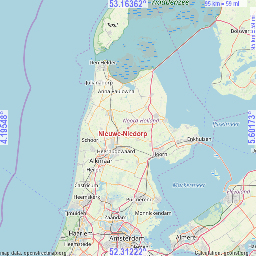
Nieuwe-Niedorp GPS coordinates[2]
52° 44' 24" North, 4° 53' 54.996" East
| Map corner | latitude | longitude |
|---|---|---|
| Upper-left | 53.16362°, | 4.19548° |
| Center: | 52.74°, | 4.89861° |
| Lower-right: | 52.31222°, | 5.60173° |
| Map W x H: | 94.7×94.7 km | = 58.8×58.8mi |
| max Lat: | 53.48025° ⇑22.1% North |
| Nieuwe-Niedorp: | 52.74° |
| min Lat: | ⇓77.9% South 50.76917° |
| min Long | Nieuwe-Niedorp | max Long |
| 3.38611° | 4.89861° | 7.16528° |
| W 23.6%⇐ | ⇒76.4% E |
Elevation
Elevation of Nieuwe-Niedorp is 2 m = 7 ft, and this is 13 m = 43 ft below average elevation for this country.
| Max E: |
203 m = 666 ft | 74.9% |
| Avg. | 15 m = 49 ft | |
| Nieuwe-Niedorp | 2 m = 7 ft | |
Min E: |
-6 m = -20 ft | 25.1% |
See also: Netherlands elevation on elevation.city.
Geographical zone
Nieuwe-Niedorp is located in North temperate zone (between Tropic of Cancer and the Arctic Circle). Distance of this North polar circle is 1537 km =955 mi to North.| Distance of | km | miles | from Nieuwe-Niedorp |
|---|---|---|---|
| North Pole | 4142.9 | 2574.3 | to North |
| Arctic Circle | 1537 | 955 | to North |
| Tropic Cancer | 3258.2 | 2024.6 | to South |
| Equator | 5864.1 | 3643.8 | to South |


Nearby cities:
15 places around Nieuwe-Niedorp: (largest is in red/bold)
• Abbekerk
8.1 km =5 mi,  96°
96°
• Barsingerhorn
5.5 km =3.4 mi,  334°
334°
• De Noord
4.8 km =3 mi,  221°
221°
• De Weere
6.6 km =4.1 mi, 102°
• Dirkshorn
8.4 km =5.2 mi,  277°
277°
• Harenkarspel
8.2 km =5.1 mi,  265°
265°
• Heerhugowaard
8.3 km =5.2 mi,  203°
203°
• Hoogwoud
3.8 km =2.4 mi,  134°
134°
• Kolhorn
6.1 km =3.8 mi,  353°
353°
• Noord-Scharwoude
7.5 km =4.7 mi,  231°
231°
• Obdam
7.2 km =4.5 mi,  175°
175°
• Opmeer
4.8 km =3 mi,  140°
140°
• Oudkarspel
6.8 km =4.2 mi,  246°
246°
• Waarland
4.7 km =2.9 mi, 251°
• Winkel
1.6 km =1 mi,  10°
10°
Sources, notices
• [Note1] Compared only with cities in Netherlands existing in our database
• [Src1] Map data: © OpenStreetMap contributors (CC-BY-SA)
• [Src2] Other city data from geonames.org with taken over terms of usage.
• [Src3] Geographical zone / Annual Mean Temperature by Robert A. Rohde @ Wikipedia
