Opmeer geodata
Opmeer (North Holland) is a populated place; located in Netherlands in Europe/Amsterdam (GMT+2) time zone. With population of 11,183 people, there are 272 cities with bigger population in this country. Compared to other cities in Netherlands, 76.7% of cities are located further ↓South; 75% of cities are located further →East and 83.9% of cities have higher elevation than Opmeer. Note1


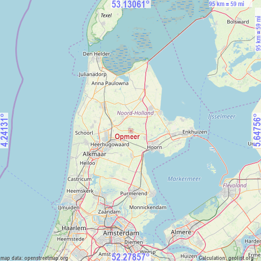
Opmeer GPS coordinates[2]
52° 42' 24.012" North, 4° 56' 39.984" East
| Map corner | latitude | longitude |
|---|---|---|
| Upper-left | 53.13061°, | 4.24131° |
| Center: | 52.70667°, | 4.94444° |
| Lower-right: | 52.27857°, | 5.64756° |
| Map W x H: | 94.7×94.7 km | = 58.8×58.8mi |
| max Lat: | 53.48025° ⇑23.3% North |
| Opmeer: | 52.70667° |
| min Lat: | ⇓76.7% South 50.76917° |
| min Long | Opmeer | max Long |
| 3.38611° | 4.94444° | 7.16528° |
| W 25%⇐ | ⇒75% E |
Elevation
Elevation of Opmeer is 1 m = 3 ft, and this is 14 m = 46 ft below average elevation for this country.
| Max E: |
203 m = 666 ft | 83.9% |
| Avg. | 15 m = 49 ft | |
| Opmeer | 1 m = 3 ft | |
Min E: |
-6 m = -20 ft | 16.1% |
See also: Netherlands elevation on elevation.city.
Geographical zone
Opmeer is located in North temperate zone (between Tropic of Cancer and the Arctic Circle). Distance of this North polar circle is 1540.7 km =957.3 mi to North.| Distance of | km | miles | from Opmeer |
|---|---|---|---|
| North Pole | 4146.6 | 2576.6 | to North |
| Arctic Circle | 1540.7 | 957.3 | to North |
| Tropic Cancer | 3254.5 | 2022.3 | to South |
| Equator | 5860.4 | 3641.5 | to South |


Nearby cities:
15 places around Opmeer: (largest is in red/bold)
• Abbekerk
5.7 km =3.5 mi,  60°
60°
• Berkhout
8.3 km =5.2 mi,  152°
152°
• De Noord
6.3 km =3.9 mi,  270°
270°
• De Weere
4 km =2.5 mi, 56°
• Heerhugowaard
7.6 km =4.7 mi,  238°
238°
• Hensbroek
6.7 km =4.2 mi,  216°
216°
• Hoogwoud
1.1 km =0.7 mi,  339°
339°
• Midwoud
8.9 km =5.5 mi,  82°
82°
• Nieuwe-Niedorp
4.8 km =3 mi,  320°
320°
• Obdam
4.3 km =2.7 mi, 216°
• Spierdijk
6.2 km =3.9 mi,  180°
180°
• Twisk
8.2 km =5.1 mi, 62°
• Waarland
7.9 km =4.9 mi,  286°
286°
• Winkel
6 km =3.7 mi,  332°
332°
• Zwaagdijk-West
8.2 km =5.1 mi,  115°
115°
Sources, notices
• [Note1] Compared only with cities in Netherlands existing in our database
• [Src1] Map data: © OpenStreetMap contributors (CC-BY-SA)
• [Src2] Other city data from geonames.org with taken over terms of usage.
• [Src3] Geographical zone / Annual Mean Temperature by Robert A. Rohde @ Wikipedia
