Skoger geodata
Skoger (Buskerud) is a populated place; located in Norway in Europe/Oslo (GMT+2) time zone. With population of 1,082 people, there are 299 cities with bigger population in this country. Compared to other cities in Norway, 72.9% of cities are located further ↑North; 52.4% of cities are located further ←West and 65.2% of cities have lower elevation than Skoger. Note1


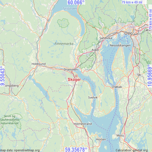
Skoger GPS coordinates[2]
59° 42' 47.772" North, 10° 15' 12.816" East
| Map corner | latitude | longitude |
|---|---|---|
| Upper-left | 60.066°, | 9.55043° |
| Center: | 59.71327°, | 10.25356° |
| Lower-right: | 59.35678°, | 10.95669° |
| Map W x H: | 78.9×78.9 km | = 49×49mi |
| max Lat: | 71.04137° ⇑72.9% North |
| Skoger: | 59.71327° |
| min Lat: | ⇓27.1% South 58.0274° |
| min Long | Skoger | max Long |
| 4.71485° | 10.25356° | 31.11066° |
| W 52.4%⇐ | ⇒47.6% E |
Elevation
Elevation of Skoger is 95 m = 312 ft, and this is 9.2 m = 30 ft below average elevation for this country.
| Max E: |
897 m = 2943 ft | 34.8% |
| Avg. | 104.2 m = 342 ft | |
| Skoger | 95 m = 312 ft | |
Min E: |
1 m = 3 ft | 65.2% |
See also: Norway elevation on elevation.city.
Geographical zone
Skoger is located in North temperate zone (between Tropic of Cancer and the Arctic Circle). Distance of this North polar circle is 761.7 km =473.3 mi to North.| Distance of | km | miles | from Skoger |
|---|---|---|---|
| North Pole | 3367.6 | 2092.5 | to North |
| Arctic Circle | 761.7 | 473.3 | to North |
| Tropic Cancer | 4033.6 | 2506.4 | to South |
| Equator | 6639.5 | 4125.6 | to South |


Nearby cities:
15 places around Skoger: (largest is in red/bold)
• Asker
16.8 km =10.4 mi,  37°
37°
• Berger
19.6 km =12.2 mi,  157°
157°
• Blakstad
16.7 km =10.4 mi,  45°
45°
• Drammen
4.4 km =2.7 mi,  321°
321°
• Fagerstrand
19.3 km =12 mi,  81°
81°
• Lierbyen
8.2 km =5.1 mi,  356°
356°
• Mjøndalen
13.5 km =8.4 mi,  288°
288°
• Røyken
8.4 km =5.2 mi,  63°
63°
• Sande
14.3 km =8.9 mi,  190°
190°
• Selvik
16.3 km =10.1 mi,  178°
178°
• Slemmestad
15.6 km =9.7 mi, 61°
• Svelvik
14.1 km =8.8 mi,  141°
141°
• Sætre
15.8 km =9.8 mi,  103°
103°
• Tranby
10.6 km =6.6 mi,  2°
2°
• Åros
14.5 km =9 mi,  93°
93°
Sources, notices
• [Note1] Compared only with cities in Norway existing in our database
• [Src1] Map data: © OpenStreetMap contributors (CC-BY-SA)
• [Src2] Other city data from geonames.org with taken over terms of usage.
• [Src3] Geographical zone / Annual Mean Temperature by Robert A. Rohde @ Wikipedia
