Sande geodata
Sande (Vestfold) is a seat of a second-order administrative division; located in Norway in Europe/Oslo (GMT+2) time zone. With population of 1,389 people, there are 250 cities with bigger population in this country. Compared to other cities in Norway, 76.4% of cities are located further ↑North; 50.8% of cities are located further ←West and 70.6% of cities have higher elevation than Sande. Note1


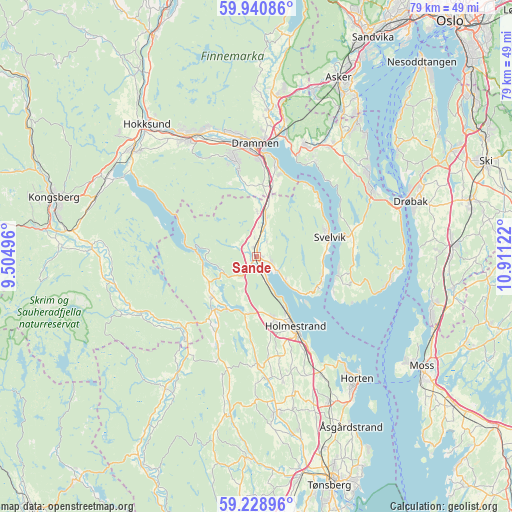
Sande GPS coordinates[2]
59° 35' 12.444" North, 10° 12' 29.124" East
| Map corner | latitude | longitude |
|---|---|---|
| Upper-left | 59.94086°, | 9.50496° |
| Center: | 59.58679°, | 10.20809° |
| Lower-right: | 59.22896°, | 10.91122° |
| Map W x H: | 79.2×79.2 km | = 49.2×49.2mi |
| max Lat: | 71.04137° ⇑76.4% North |
| Sande: | 59.58679° |
| min Lat: | ⇓23.6% South 58.0274° |
| min Long | Sande | max Long |
| 4.71485° | 10.20809° | 31.11066° |
| W 50.8%⇐ | ⇒49.2% E |
Elevation
Elevation of Sande is 18 m = 59 ft, and this is 86.2 m = 283 ft below average elevation for this country.
| Max E: |
897 m = 2943 ft | 70.6% |
| Avg. | 104.2 m = 342 ft | |
| Sande | 18 m = 59 ft | |
Min E: |
1 m = 3 ft | 29.4% |
See also: Norway elevation on elevation.city.
Geographical zone
Sande is located in North temperate zone (between Tropic of Cancer and the Arctic Circle). Distance of this North polar circle is 775.7 km =482 mi to North.| Distance of | km | miles | from Sande |
|---|---|---|---|
| North Pole | 3381.6 | 2101.2 | to North |
| Arctic Circle | 775.7 | 482 | to North |
| Tropic Cancer | 4019.5 | 2497.6 | to South |
| Equator | 6625.4 | 4116.8 | to South |


Nearby cities:
15 places around Sande: (largest is in red/bold)
• Berger
10.8 km =6.7 mi,  112°
112°
• Drammen
17.5 km =10.9 mi,  359°
359°
• Gullhaug
9.8 km =6.1 mi,  165°
165°
• Holmestrand
12.6 km =7.8 mi,  150°
150°
• Hvittingfoss
15.8 km =9.8 mi,  224°
224°
• Lierbyen
22.3 km =13.9 mi,  5°
5°
• Mjøndalen
20.9 km =13 mi,  330°
330°
• Nykirke
20.8 km =12.9 mi, 151°
• Røyken
20.5 km =12.7 mi,  29°
29°
• Selvik
3.7 km =2.3 mi,  127°
127°
• Skoger
14.3 km =8.9 mi, 10°
• Svelvik
11.7 km =7.3 mi,  75°
75°
• Sætre
20.8 km =12.9 mi,  59°
59°
• Tofte
20.5 km =12.7 mi,  103°
103°
• Åros
21.6 km =13.4 mi,  52°
52°
Sources, notices
• [Note1] Compared only with cities in Norway existing in our database
• [Src1] Map data: © OpenStreetMap contributors (CC-BY-SA)
• [Src2] Other city data from geonames.org with taken over terms of usage.
• [Src3] Geographical zone / Annual Mean Temperature by Robert A. Rohde @ Wikipedia
