Fyresdal geodata
Fyresdal (Telemark) is a seat of a second-order administrative division; located in Norway in Europe/Oslo (GMT+2) time zone. With population of 359 people, there are 474 cities with bigger population in this country. Compared to other cities in Norway, 87.2% of cities are located further ↑North; 66.1% of cities are located further →East and 90.7% of cities have lower elevation than Fyresdal. Note1


Fyresdal GPS coordinates[2]
59° 11' 0.348" North, 8° 5' 31.56" East
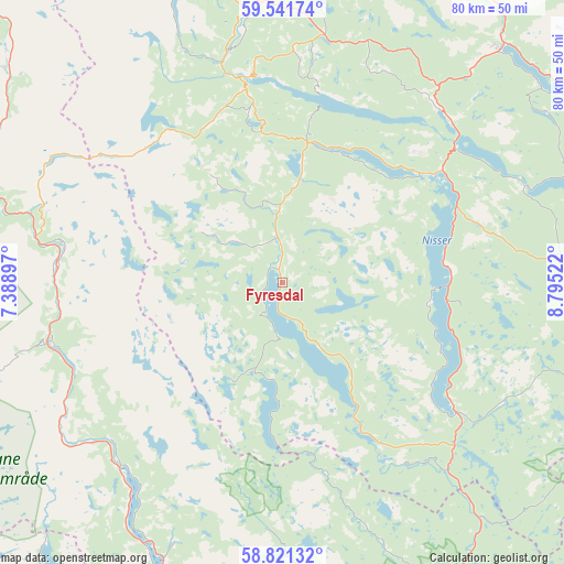
| Map corner | latitude | longitude |
|---|---|---|
| Upper-left | 59.54174°, | 7.38897° |
| Center: | 59.18343°, | 8.0921° |
| Lower-right: | 58.82132°, | 8.79522° |
| Map W x H: | 80.1×80.1 km | = 49.8×49.8mi |
| max Lat: | 71.04137° ⇑87.2% North |
| Fyresdal: | 59.18343° |
| min Lat: | ⇓12.8% South 58.0274° |
| min Long | Fyresdal | max Long |
| 4.71485° | 8.0921° | 31.11066° |
| W 33.9%⇐ | ⇒66.1% E |
Elevation
Elevation of Fyresdal is 295 m = 968 ft, and this is 190.8 m = 626 ft above average elevation for this country.
| Max E: |
897 m = 2943 ft | 9.3% |
| Fyresdal | 295 m 968 ft | |
| Avg. | 104.2 m = 342 ft | |
Min E: |
1 m = 3 ft | 90.7% |
See also: Norway elevation on elevation.city.
Geographical zone
Fyresdal is located in North temperate zone (between Tropic of Cancer and the Arctic Circle). Distance of this North polar circle is 820.6 km =509.9 mi to North.| Distance of | km | miles | from Fyresdal |
|---|---|---|---|
| North Pole | 3426.5 | 2129.1 | to North |
| Arctic Circle | 820.6 | 509.9 | to North |
| Tropic Cancer | 3974.7 | 2469.8 | to South |
| Equator | 6580.6 | 4089 | to South |


Nearby cities:
15 places around Fyresdal: (largest is in red/bold)
• Bygland
42.9 km =26.7 mi,  203°
203°
• Bø
61.1 km =38 mi,  65°
65°
• Dalen
29.5 km =18.3 mi,  350°
350°
• Gjerstad
62.8 km =39 mi,  122°
122°
• Gvarv
65.4 km =40.6 mi, 69°
• Hovden
59.1 km =36.7 mi,  315°
315°
• Kviteseid
33.3 km =20.7 mi,  43°
43°
• Lunde
58.9 km =36.6 mi,  77°
77°
• Prestestranda
55.9 km =34.7 mi,  99°
99°
• Seljord
45.3 km =28.1 mi, 42°
• Treungen
30.4 km =18.9 mi,  126°
126°
• Valle
31.9 km =19.8 mi,  275°
275°
• Åmli
51.6 km =32.1 mi,  154°
154°
• Åmot
43.4 km =27 mi, 352°
• Åmot
52.4 km =32.6 mi,  17°
17°
Sources, notices
• [Note1] Compared only with cities in Norway existing in our database
• [Src1] Map data: © OpenStreetMap contributors (CC-BY-SA)
• [Src2] Other city data from geonames.org with taken over terms of usage.
• [Src3] Geographical zone / Annual Mean Temperature by Robert A. Rohde @ Wikipedia
