Bygland geodata
Bygland (Aust-Agder) is a seat of a second-order administrative division; located in Norway in Europe/Oslo (GMT+2) time zone. In our database, there are 488 cities with bigger population. Compared to other cities in Norway, 92.1% of cities are located further ↑North; 68.7% of cities are located further →East and 85.6% of cities have lower elevation than Bygland. Note1


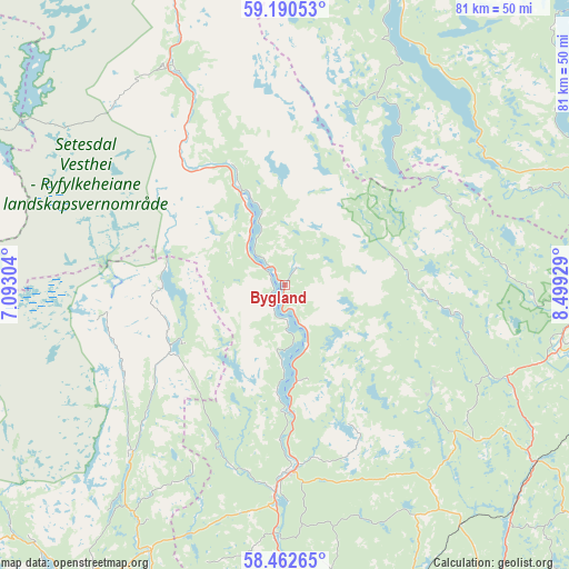
Bygland GPS coordinates[2]
58° 49' 42.6" North, 7° 47' 46.176" East
| Map corner | latitude | longitude |
|---|---|---|
| Upper-left | 59.19053°, | 7.09304° |
| Center: | 58.8285°, | 7.79616° |
| Lower-right: | 58.46265°, | 8.49929° |
| Map W x H: | 80.9×80.9 km | = 50.3×50.3mi |
| max Lat: | 71.04137° ⇑92.1% North |
| Bygland: | 58.8285° |
| min Lat: | ⇓7.9% South 58.0274° |
| min Long | Bygland | max Long |
| 4.71485° | 7.79616° | 31.11066° |
| W 31.3%⇐ | ⇒68.7% E |
Elevation
Elevation of Bygland is 207 m = 679 ft, and this is 102.8 m = 337 ft above average elevation for this country.
| Max E: |
897 m = 2943 ft | 14.4% |
| Bygland | 207 m 679 ft | |
| Avg. | 104.2 m = 342 ft | |
Min E: |
1 m = 3 ft | 85.6% |
See also: Norway elevation on elevation.city.
Geographical zone
Bygland is located in North temperate zone (between Tropic of Cancer and the Arctic Circle). Distance of this North polar circle is 860.1 km =534.4 mi to North.| Distance of | km | miles | from Bygland |
|---|---|---|---|
| North Pole | 3465.9 | 2153.6 | to North |
| Arctic Circle | 860.1 | 534.4 | to North |
| Tropic Cancer | 3935.2 | 2445.2 | to South |
| Equator | 6541.1 | 4064.4 | to South |


Nearby cities:
15 places around Bygland: (largest is in red/bold)
• Birkeland
60.8 km =37.8 mi,  155°
155°
• Birketveit
41.7 km =25.9 mi,  170°
170°
• Blakstad
60.9 km =37.8 mi,  126°
126°
• Evje
27 km =16.8 mi,  179°
179°
• Fyresdal
42.9 km =26.7 mi,  23°
23°
• Konsmo
65.6 km =40.8 mi,  202°
202°
• Kyrkjebygda
32.4 km =20.1 mi,  222°
222°
• Myra
62.1 km =38.6 mi,  98°
98°
• Rykene
67.4 km =41.9 mi, 133°
• Tingvatn
60.4 km =37.5 mi,  213°
213°
• Tonstad
64.9 km =40.3 mi,  253°
253°
• Treungen
46.7 km =29 mi,  62°
62°
• Valle
45.2 km =28.1 mi,  340°
340°
• Vennesla
63.1 km =39.2 mi, 170°
• Åmli
40.2 km =25 mi, 100°
Sources, notices
• [Note1] Compared only with cities in Norway existing in our database
• [Src1] Map data: © OpenStreetMap contributors (CC-BY-SA)
• [Src2] Other city data from geonames.org with taken over terms of usage.
• [Src3] Geographical zone / Annual Mean Temperature by Robert A. Rohde @ Wikipedia
