Treungen geodata
Treungen (Telemark) is a seat of a second-order administrative division; located in Norway in Europe/Oslo (GMT+2) time zone. In our database, there are 488 cities with bigger population. Compared to other cities in Norway, 89.9% of cities are located further ↑North; 63.9% of cities are located further →East and 88.6% of cities have lower elevation than Treungen. Note1


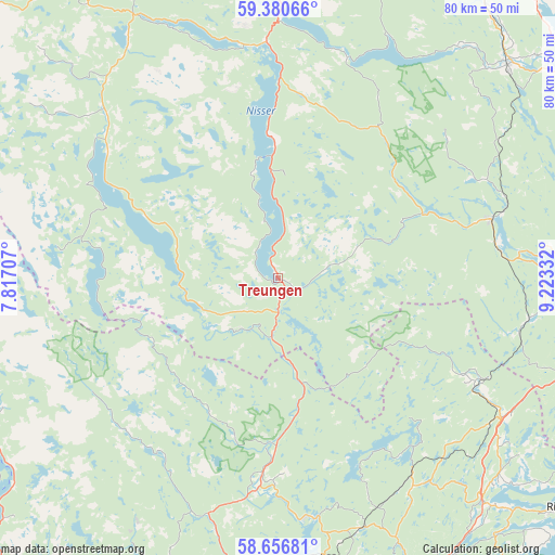
Treungen GPS coordinates[2]
59° 1' 14.304" North, 8° 31' 12.72" East
| Map corner | latitude | longitude |
|---|---|---|
| Upper-left | 59.38066°, | 7.81707° |
| Center: | 59.02064°, | 8.5202° |
| Lower-right: | 58.65681°, | 9.22332° |
| Map W x H: | 80.5×80.5 km | = 50×50mi |
| max Lat: | 71.04137° ⇑89.9% North |
| Treungen: | 59.02064° |
| min Lat: | ⇓10.1% South 58.0274° |
| min Long | Treungen | max Long |
| 4.71485° | 8.5202° | 31.11066° |
| W 36.1%⇐ | ⇒63.9% E |
Elevation
Elevation of Treungen is 260 m = 853 ft, and this is 155.8 m = 511 ft above average elevation for this country.
| Max E: |
897 m = 2943 ft | 11.4% |
| Treungen | 260 m 853 ft | |
| Avg. | 104.2 m = 342 ft | |
Min E: |
1 m = 3 ft | 88.6% |
See also: Norway elevation on elevation.city.
Geographical zone
Treungen is located in North temperate zone (between Tropic of Cancer and the Arctic Circle). Distance of this North polar circle is 838.7 km =521.1 mi to North.| Distance of | km | miles | from Treungen |
|---|---|---|---|
| North Pole | 3444.6 | 2140.4 | to North |
| Arctic Circle | 838.7 | 521.1 | to North |
| Tropic Cancer | 3956.6 | 2458.5 | to South |
| Equator | 6562.5 | 4077.7 | to South |


Nearby cities:
15 places around Treungen: (largest is in red/bold)
• Bygland
46.7 km =29 mi,  242°
242°
• Bø
53.7 km =33.4 mi,  35°
35°
• Fyresdal
30.4 km =18.9 mi,  306°
306°
• Gjerstad
32.5 km =20.2 mi,  118°
118°
• Kil
47 km =29.2 mi,  107°
107°
• Kragerø
54 km =33.6 mi, 108°
• Kviteseid
42.5 km =26.4 mi,  357°
357°
• Lunde
45.3 km =28.1 mi,  47°
47°
• Myra
36 km =22.4 mi,  146°
146°
• Prestestranda
32 km =19.9 mi,  74°
74°
• Risør
52.9 km =32.9 mi,  129°
129°
• Seljord
52 km =32.3 mi,  6°
6°
• Tvedestrand
50.2 km =31.2 mi, 151°
• Ulefoss
51.5 km =32 mi,  55°
55°
• Åmli
28.4 km =17.6 mi,  184°
184°
Sources, notices
• [Note1] Compared only with cities in Norway existing in our database
• [Src1] Map data: © OpenStreetMap contributors (CC-BY-SA)
• [Src2] Other city data from geonames.org with taken over terms of usage.
• [Src3] Geographical zone / Annual Mean Temperature by Robert A. Rohde @ Wikipedia
