Prestestranda geodata
Prestestranda (Telemark) is a seat of a second-order administrative division; located in Norway in Europe/Oslo (GMT+2) time zone. With population of 1,215 people, there are 267 cities with bigger population in this country. Compared to other cities in Norway, 88.6% of cities are located further ↑North; 59.7% of cities are located further →East and 67.6% of cities have lower elevation than Prestestranda. Note1


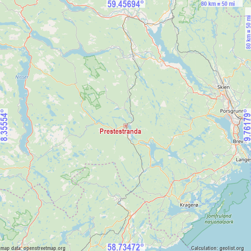
Prestestranda GPS coordinates[2]
59° 5' 51.828" North, 9° 3' 31.176" East
| Map corner | latitude | longitude |
|---|---|---|
| Upper-left | 59.45694°, | 8.35554° |
| Center: | 59.09773°, | 9.05866° |
| Lower-right: | 58.73472°, | 9.76179° |
| Map W x H: | 80.3×80.3 km | = 49.9×49.9mi |
| max Lat: | 71.04137° ⇑88.6% North |
| Prestestranda: | 59.09773° |
| min Lat: | ⇓11.4% South 58.0274° |
| min Long | Prestestranda | max Long |
| 4.71485° | 9.05866° | 31.11066° |
| W 40.3%⇐ | ⇒59.7% E |
Elevation
Elevation of Prestestranda is 109 m = 358 ft, and this is 4.8 m = 16 ft above average elevation for this country.
| Max E: |
897 m = 2943 ft | 32.4% |
| Prestestranda | 109 m 358 ft | |
| Avg. | 104.2 m = 342 ft | |
Min E: |
1 m = 3 ft | 67.6% |
See also: Norway elevation on elevation.city.
Geographical zone
Prestestranda is located in North temperate zone (between Tropic of Cancer and the Arctic Circle). Distance of this North polar circle is 830.1 km =515.8 mi to North.| Distance of | km | miles | from Prestestranda |
|---|---|---|---|
| North Pole | 3436 | 2135 | to North |
| Arctic Circle | 830.1 | 515.8 | to North |
| Tropic Cancer | 3965.1 | 2463.8 | to South |
| Equator | 6571.1 | 4083.1 | to South |


Nearby cities:
15 places around Prestestranda: (largest is in red/bold)
• Bø
35.1 km =21.8 mi,  0°
0°
• Gjerstad
24.2 km =15 mi,  185°
185°
• Gvarv
32.9 km =20.4 mi,  11°
11°
• Herre
28.7 km =17.8 mi,  88°
88°
• Kil
26.8 km =16.7 mi,  148°
148°
• Kragerø
32.6 km =20.3 mi,  141°
141°
• Langangen
42.6 km =26.5 mi, 91°
• Langesund
40.9 km =25.4 mi,  105°
105°
• Lunde
22.4 km =13.9 mi, 6°
• Myra
40.4 km =25.1 mi,  196°
196°
• Porsgrunn
34.4 km =21.4 mi,  82°
82°
• Siljan
42.7 km =26.5 mi,  60°
60°
• Skien
33.8 km =21 mi,  68°
68°
• Treungen
32 km =19.9 mi,  254°
254°
• Ulefoss
23.7 km =14.7 mi,  29°
29°
Sources, notices
• [Note1] Compared only with cities in Norway existing in our database
• [Src1] Map data: © OpenStreetMap contributors (CC-BY-SA)
• [Src2] Other city data from geonames.org with taken over terms of usage.
• [Src3] Geographical zone / Annual Mean Temperature by Robert A. Rohde @ Wikipedia
