Valle geodata
Valle (Aust-Agder) is a seat of a second-order administrative division; located in Norway in Europe/Oslo (GMT+2) time zone. In our database, there are 488 cities with bigger population. Compared to other cities in Norway, 86.4% of cities are located further ↑North; 69.8% of cities are located further →East and 91.3% of cities have lower elevation than Valle. Note1


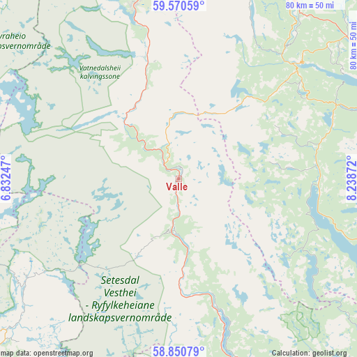
Valle GPS coordinates[2]
59° 12' 45.324" North, 7° 32' 8.124" East
| Map corner | latitude | longitude |
|---|---|---|
| Upper-left | 59.57059°, | 6.83247° |
| Center: | 59.21259°, | 7.53559° |
| Lower-right: | 58.85079°, | 8.23872° |
| Map W x H: | 80×80 km | = 49.7×49.7mi |
| max Lat: | 71.04137° ⇑86.4% North |
| Valle: | 59.21259° |
| min Lat: | ⇓13.6% South 58.0274° |
| min Long | Valle | max Long |
| 4.71485° | 7.53559° | 31.11066° |
| W 30.2%⇐ | ⇒69.8% E |
Elevation
Elevation of Valle is 319 m = 1047 ft, and this is 214.8 m = 705 ft above average elevation for this country.
| Max E: |
897 m = 2943 ft | 8.7% |
| Valle | 319 m 1047 ft | |
| Avg. | 104.2 m = 342 ft | |
Min E: |
1 m = 3 ft | 91.3% |
See also: Norway elevation on elevation.city.
Geographical zone
Valle is located in North temperate zone (between Tropic of Cancer and the Arctic Circle). Distance of this North polar circle is 817.4 km =507.9 mi to North.| Distance of | km | miles | from Valle |
|---|---|---|---|
| North Pole | 3423.2 | 2127.1 | to North |
| Arctic Circle | 817.4 | 507.9 | to North |
| Tropic Cancer | 3977.9 | 2471.8 | to South |
| Equator | 6583.8 | 4091 | to South |


Nearby cities:
15 places around Valle: (largest is in red/bold)
• Bygland
45.2 km =28.1 mi,  160°
160°
• Dalen
37.1 km =23.1 mi,  45°
45°
• Evje
71.4 km =44.4 mi,  167°
167°
• Fyresdal
31.9 km =19.8 mi,  95°
95°
• Hjelmelandsvågen
77.2 km =48 mi,  272°
272°
• Hovden
40 km =24.9 mi,  345°
345°
• Kviteseid
58.3 km =36.2 mi,  68°
68°
• Kyrkjebygda
66.8 km =41.5 mi,  186°
186°
• Sand
78.8 km =49 mi,  292°
292°
• Seljord
69 km =42.9 mi,  63°
63°
• Tonstad
77.1 km =47.9 mi,  217°
217°
• Treungen
60.1 km =37.3 mi,  110°
110°
• Åmli
73.6 km =45.7 mi,  132°
132°
• Åmot
47.3 km =29.4 mi,  32°
32°
• Åmot
66.3 km =41.2 mi, 45°
Sources, notices
• [Note1] Compared only with cities in Norway existing in our database
• [Src1] Map data: © OpenStreetMap contributors (CC-BY-SA)
• [Src2] Other city data from geonames.org with taken over terms of usage.
• [Src3] Geographical zone / Annual Mean Temperature by Robert A. Rohde @ Wikipedia
