Knappstad geodata
Knappstad (Østfold) is a populated place; located in Norway in Europe/Oslo (GMT+2) time zone. With population of 1,133 people, there are 289 cities with bigger population in this country. Compared to other cities in Norway, 75.2% of cities are located further ↑North; 67.7% of cities are located further ←West and 70.3% of cities have lower elevation than Knappstad. Note1


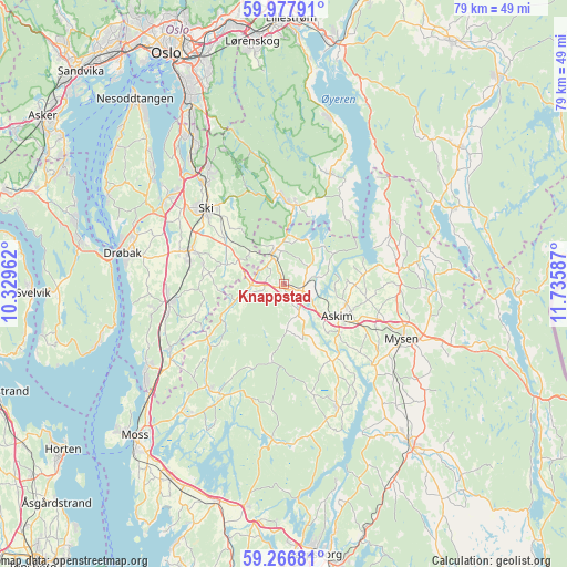
Knappstad GPS coordinates[2]
59° 37' 27.264" North, 11° 1' 57.864" East
| Map corner | latitude | longitude |
|---|---|---|
| Upper-left | 59.97791°, | 10.32962° |
| Center: | 59.62424°, | 11.03274° |
| Lower-right: | 59.26681°, | 11.73587° |
| Map W x H: | 79.1×79.1 km | = 49.2×49.2mi |
| max Lat: | 71.04137° ⇑75.2% North |
| Knappstad: | 59.62424° |
| min Lat: | ⇓24.8% South 58.0274° |
| min Long | Knappstad | max Long |
| 4.71485° | 11.03274° | 31.11066° |
| W 67.7%⇐ | ⇒32.3% E |
Elevation
Elevation of Knappstad is 121 m = 397 ft, and this is 16.8 m = 55 ft above average elevation for this country.
| Max E: |
897 m = 2943 ft | 29.7% |
| Knappstad | 121 m 397 ft | |
| Avg. | 104.2 m = 342 ft | |
Min E: |
1 m = 3 ft | 70.3% |
See also: Norway elevation on elevation.city.
Geographical zone
Knappstad is located in North temperate zone (between Tropic of Cancer and the Arctic Circle). Distance of this North polar circle is 771.6 km =479.4 mi to North.| Distance of | km | miles | from Knappstad |
|---|---|---|---|
| North Pole | 3377.5 | 2098.7 | to North |
| Arctic Circle | 771.6 | 479.4 | to North |
| Tropic Cancer | 4023.7 | 2500.2 | to South |
| Equator | 6629.6 | 4119.4 | to South |


Nearby cities:
15 places around Knappstad: (largest is in red/bold)
• Askim
8.6 km =5.3 mi,  121°
121°
• Drøbak
23.1 km =14.4 mi,  280°
280°
• Elvestad
4.6 km =2.9 mi,  269°
269°
• Flateby
23.8 km =14.8 mi,  16°
16°
• Heiås
17.1 km =10.6 mi,  60°
60°
• Kirkebygda
16.8 km =10.4 mi, 21°
• Kirkebygda
17.2 km =10.7 mi,  211°
211°
• Meieribyen
18.1 km =11.2 mi,  156°
156°
• Mysen
18.3 km =11.4 mi, 115°
• Ski
15.3 km =9.5 mi,  313°
313°
• Skjønhaug
16 km =9.9 mi,  83°
83°
• Spydeberg
3.1 km =1.9 mi,  104°
104°
• Tomter
4.4 km =2.7 mi,  331°
331°
• Vestby
15.9 km =9.9 mi,  262°
262°
• Ås
14.1 km =8.8 mi,  288°
288°
Sources, notices
• [Note1] Compared only with cities in Norway existing in our database
• [Src1] Map data: © OpenStreetMap contributors (CC-BY-SA)
• [Src2] Other city data from geonames.org with taken over terms of usage.
• [Src3] Geographical zone / Annual Mean Temperature by Robert A. Rohde @ Wikipedia
