Mysen geodata
Mysen (Østfold) is a seat of a second-order administrative division; located in Norway in Europe/Oslo (GMT+2) time zone. With population of 5,516 people, there are 85 cities with bigger population in this country. Compared to other cities in Norway, 77.4% of cities are located further ↑North; 75% of cities are located further ←West and 68.2% of cities have lower elevation than Mysen. Note1


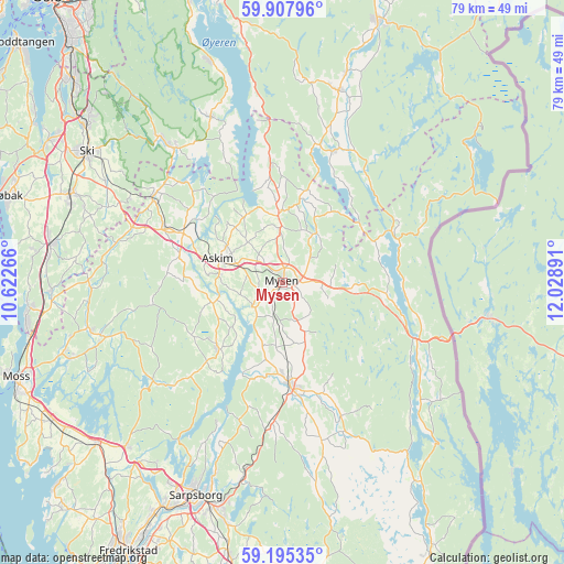
Mysen GPS coordinates[2]
59° 33' 12.744" North, 11° 19' 32.808" East
| Map corner | latitude | longitude |
|---|---|---|
| Upper-left | 59.90796°, | 10.62266° |
| Center: | 59.55354°, | 11.32578° |
| Lower-right: | 59.19535°, | 12.02891° |
| Map W x H: | 79.2×79.2 km | = 49.2×49.2mi |
| max Lat: | 71.04137° ⇑77.4% North |
| Mysen: | 59.55354° |
| min Lat: | ⇓22.6% South 58.0274° |
| min Long | Mysen | max Long |
| 4.71485° | 11.32578° | 31.11066° |
| W 75%⇐ | ⇒25% E |
Elevation
Elevation of Mysen is 114 m = 374 ft, and this is 9.8 m = 32 ft above average elevation for this country.
| Max E: |
897 m = 2943 ft | 31.8% |
| Mysen | 114 m 374 ft | |
| Avg. | 104.2 m = 342 ft | |
Min E: |
1 m = 3 ft | 68.2% |
See also: Norway elevation on elevation.city.
Geographical zone
Mysen is located in North temperate zone (between Tropic of Cancer and the Arctic Circle). Distance of this North polar circle is 779.4 km =484.3 mi to North.| Distance of | km | miles | from Mysen |
|---|---|---|---|
| North Pole | 3385.3 | 2103.5 | to North |
| Arctic Circle | 779.4 | 484.3 | to North |
| Tropic Cancer | 4015.8 | 2495.3 | to South |
| Equator | 6621.7 | 4114.5 | to South |


Nearby cities:
15 places around Mysen: (largest is in red/bold)
• Askim
9.8 km =6.1 mi,  289°
289°
• Elvestad
22.5 km =14 mi, 290°
• Heiås
16.3 km =10.1 mi,  354°
354°
• Hemnes
20 km =12.4 mi,  21°
21°
• Ise
28.8 km =17.9 mi,  191°
191°
• Kirkebygda
25.6 km =15.9 mi,  336°
336°
• Kirkebygda
26.4 km =16.4 mi,  254°
254°
• Knappstad
18.3 km =11.4 mi,  295°
295°
• Løken
28 km =17.4 mi, 16°
• Meieribyen
12.8 km =8 mi,  226°
226°
• Rakkestad
14.3 km =8.9 mi,  175°
175°
• Skjønhaug
9.7 km =6 mi,  356°
356°
• Spydeberg
15.3 km =9.5 mi, 297°
• Tomter
22 km =13.7 mi, 302°
• Ørje
20.5 km =12.7 mi,  113°
113°
Sources, notices
• [Note1] Compared only with cities in Norway existing in our database
• [Src1] Map data: © OpenStreetMap contributors (CC-BY-SA)
• [Src2] Other city data from geonames.org with taken over terms of usage.
• [Src3] Geographical zone / Annual Mean Temperature by Robert A. Rohde @ Wikipedia
