Kirkebygda geodata
Kirkebygda (Akershus) is a seat of a second-order administrative division; located in Norway in Europe/Oslo (GMT+2) time zone. In our database, there are 488 cities with bigger population. Compared to other cities in Norway, 71.5% of cities are located further ↑North; 70.3% of cities are located further ←West and 79.7% of cities have lower elevation than Kirkebygda. Note1


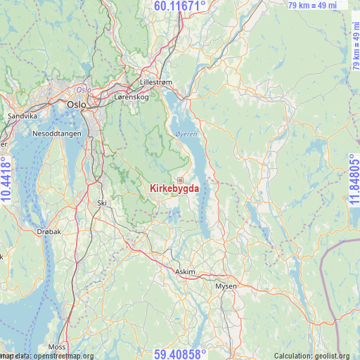
Kirkebygda GPS coordinates[2]
59° 45' 52.272" North, 11° 8' 41.712" East
| Map corner | latitude | longitude |
|---|---|---|
| Upper-left | 60.11671°, | 10.4418° |
| Center: | 59.76452°, | 11.14492° |
| Lower-right: | 59.40858°, | 11.84805° |
| Map W x H: | 78.7×78.7 km | = 48.9×48.9mi |
| max Lat: | 71.04137° ⇑71.5% North |
| Kirkebygda: | 59.76452° |
| min Lat: | ⇓28.5% South 58.0274° |
| min Long | Kirkebygda | max Long |
| 4.71485° | 11.14492° | 31.11066° |
| W 70.3%⇐ | ⇒29.7% E |
Elevation
Elevation of Kirkebygda is 167 m = 548 ft, and this is 62.8 m = 206 ft above average elevation for this country.
| Max E: |
897 m = 2943 ft | 20.3% |
| Kirkebygda | 167 m 548 ft | |
| Avg. | 104.2 m = 342 ft | |
Min E: |
1 m = 3 ft | 79.7% |
See also: Norway elevation on elevation.city.
Geographical zone
Kirkebygda is located in North temperate zone (between Tropic of Cancer and the Arctic Circle). Distance of this North polar circle is 756 km =469.8 mi to North.| Distance of | km | miles | from Kirkebygda |
|---|---|---|---|
| North Pole | 3361.9 | 2089 | to North |
| Arctic Circle | 756 | 469.8 | to North |
| Tropic Cancer | 4039.3 | 2509.9 | to South |
| Equator | 6645.2 | 4129.1 | to South |


Nearby cities:
15 places around Kirkebygda: (largest is in red/bold)
• Askim
20.2 km =12.6 mi,  177°
177°
• Elvestad
19 km =11.8 mi,  214°
214°
• Fetsund
17.8 km =11.1 mi,  2°
2°
• Fjerdingby
18.5 km =11.5 mi,  346°
346°
• Flateby
7.2 km =4.5 mi, 3°
• Fosser
20.1 km =12.5 mi,  72°
72°
• Heiås
11.2 km =7 mi,  129°
129°
• Hemnes
18.1 km =11.2 mi,  105°
105°
• Knappstad
16.8 km =10.4 mi,  201°
201°
• Kolbotn
19.8 km =12.3 mi,  285°
285°
• Løken
18.3 km =11.4 mi,  79°
79°
• Ski
18 km =11.2 mi,  253°
253°
• Skjønhaug
16.8 km =10.4 mi,  145°
145°
• Spydeberg
16.7 km =10.4 mi,  191°
191°
• Tomter
14.4 km =8.9 mi,  215°
215°
Sources, notices
• [Note1] Compared only with cities in Norway existing in our database
• [Src1] Map data: © OpenStreetMap contributors (CC-BY-SA)
• [Src2] Other city data from geonames.org with taken over terms of usage.
• [Src3] Geographical zone / Annual Mean Temperature by Robert A. Rohde @ Wikipedia
