Skjønhaug geodata
Skjønhaug (Østfold) is a seat of a second-order administrative division; located in Norway in Europe/Oslo (GMT+2) time zone. In our database, there are 488 cities with bigger population. Compared to other cities in Norway, 74.8% of cities are located further ↑North; 74.8% of cities are located further ←West and 81% of cities have lower elevation than Skjønhaug. Note1


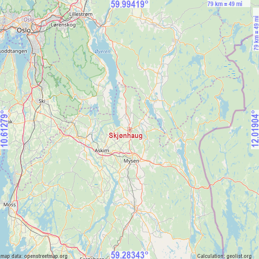
Skjønhaug GPS coordinates[2]
59° 38' 26.484" North, 11° 18' 57.276" East
| Map corner | latitude | longitude |
|---|---|---|
| Upper-left | 59.99419°, | 10.61279° |
| Center: | 59.64069°, | 11.31591° |
| Lower-right: | 59.28343°, | 12.01904° |
| Map W x H: | 79×79 km | = 49.1×49.1mi |
| max Lat: | 71.04137° ⇑74.8% North |
| Skjønhaug: | 59.64069° |
| min Lat: | ⇓25.2% South 58.0274° |
| min Long | Skjønhaug | max Long |
| 4.71485° | 11.31591° | 31.11066° |
| W 74.8%⇐ | ⇒25.2% E |
Elevation
Elevation of Skjønhaug is 177 m = 581 ft, and this is 72.8 m = 239 ft above average elevation for this country.
| Max E: |
897 m = 2943 ft | 19% |
| Skjønhaug | 177 m 581 ft | |
| Avg. | 104.2 m = 342 ft | |
Min E: |
1 m = 3 ft | 81% |
See also: Norway elevation on elevation.city.
Geographical zone
Skjønhaug is located in North temperate zone (between Tropic of Cancer and the Arctic Circle). Distance of this North polar circle is 769.8 km =478.3 mi to North.| Distance of | km | miles | from Skjønhaug |
|---|---|---|---|
| North Pole | 3375.6 | 2097.5 | to North |
| Arctic Circle | 769.8 | 478.3 | to North |
| Tropic Cancer | 4025.5 | 2501.3 | to South |
| Equator | 6631.4 | 4120.6 | to South |


Nearby cities:
15 places around Skjønhaug: (largest is in red/bold)
• Askim
10.7 km =6.6 mi,  233°
233°
• Elvestad
20.6 km =12.8 mi,  264°
264°
• Flateby
22.9 km =14.2 mi,  336°
336°
• Fosser
22.1 km =13.7 mi,  25°
25°
• Heiås
6.6 km =4.1 mi,  351°
351°
• Hemnes
11.9 km =7.4 mi,  41°
41°
• Kirkebygda
16.8 km =10.4 mi,  325°
325°
• Knappstad
16 km =9.9 mi, 263°
• Løken
19.2 km =11.9 mi, 26°
• Meieribyen
20.4 km =12.7 mi,  205°
205°
• Mysen
9.7 km =6 mi,  176°
176°
• Rakkestad
24 km =14.9 mi, 176°
• Spydeberg
13.2 km =8.2 mi, 258°
• Tomter
18.2 km =11.3 mi,  276°
276°
• Ørje
26.4 km =16.4 mi,  132°
132°
Sources, notices
• [Note1] Compared only with cities in Norway existing in our database
• [Src1] Map data: © OpenStreetMap contributors (CC-BY-SA)
• [Src2] Other city data from geonames.org with taken over terms of usage.
• [Src3] Geographical zone / Annual Mean Temperature by Robert A. Rohde @ Wikipedia
