Elvestad geodata
Elvestad (Østfold) is a seat of a second-order administrative division; located in Norway in Europe/Oslo (GMT+2) time zone. In our database, there are 488 cities with bigger population. Compared to other cities in Norway, 75.3% of cities are located further ↑North; 66.6% of cities are located further ←West and 60.9% of cities have lower elevation than Elvestad. Note1


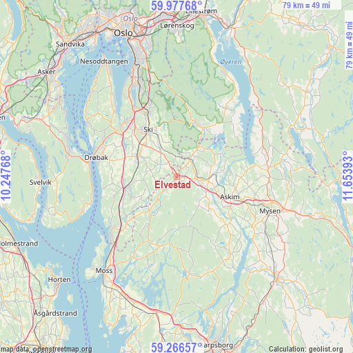
Elvestad GPS coordinates[2]
59° 37' 26.436" North, 10° 57' 2.88" East
| Map corner | latitude | longitude |
|---|---|---|
| Upper-left | 59.97768°, | 10.24768° |
| Center: | 59.62401°, | 10.9508° |
| Lower-right: | 59.26657°, | 11.65393° |
| Map W x H: | 79.1×79.1 km | = 49.2×49.2mi |
| max Lat: | 71.04137° ⇑75.3% North |
| Elvestad: | 59.62401° |
| min Lat: | ⇓24.7% South 58.0274° |
| min Long | Elvestad | max Long |
| 4.71485° | 10.9508° | 31.11066° |
| W 66.6%⇐ | ⇒33.4% E |
Elevation
Elevation of Elvestad is 70 m = 230 ft, and this is 34.2 m = 112 ft below average elevation for this country.
| Max E: |
897 m = 2943 ft | 39.1% |
| Avg. | 104.2 m = 342 ft | |
| Elvestad | 70 m = 230 ft | |
Min E: |
1 m = 3 ft | 60.9% |
See also: Norway elevation on elevation.city.
Geographical zone
Elvestad is located in North temperate zone (between Tropic of Cancer and the Arctic Circle). Distance of this North polar circle is 771.6 km =479.4 mi to North.| Distance of | km | miles | from Elvestad |
|---|---|---|---|
| North Pole | 3377.5 | 2098.7 | to North |
| Arctic Circle | 771.6 | 479.4 | to North |
| Tropic Cancer | 4023.6 | 2500.1 | to South |
| Equator | 6629.6 | 4119.4 | to South |


Nearby cities:
15 places around Elvestad: (largest is in red/bold)
• Askim
12.8 km =8 mi,  110°
110°
• Drøbak
18.6 km =11.6 mi,  283°
283°
• Heiås
21.2 km =13.2 mi,  66°
66°
• Kirkebygda
15.3 km =9.5 mi,  196°
196°
• Kirkebygda
19 km =11.8 mi,  34°
34°
• Knappstad
4.6 km =2.9 mi,  89°
89°
• Kolbotn
22.3 km =13.9 mi,  338°
338°
• Meieribyen
20.4 km =12.7 mi,  144°
144°
• Mysen
22.5 km =14 mi, 110°
• Ski
12.4 km =7.7 mi,  328°
328°
• Skjønhaug
20.6 km =12.8 mi,  84°
84°
• Spydeberg
7.6 km =4.7 mi,  95°
95°
• Tomter
4.6 km =2.9 mi, 32°
• Vestby
11.4 km =7.1 mi,  259°
259°
• Ås
9.9 km =6.2 mi,  297°
297°
Sources, notices
• [Note1] Compared only with cities in Norway existing in our database
• [Src1] Map data: © OpenStreetMap contributors (CC-BY-SA)
• [Src2] Other city data from geonames.org with taken over terms of usage.
• [Src3] Geographical zone / Annual Mean Temperature by Robert A. Rohde @ Wikipedia
