Fosnavåg geodata
Fosnavåg (Møre og Romsdal) is a seat of a second-order administrative division; located in Norway in Europe/Oslo (GMT+2) time zone. In our database, there are 488 cities with bigger population. Compared to other cities in Norway, 66.1% of cities are located further ↓South; 88.4% of cities are located further →East and 100% of cities have higher elevation than Fosnavåg. Note1


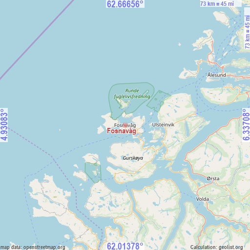
Fosnavåg GPS coordinates[2]
62° 20' 30.984" North, 5° 38' 2.256" East
| Map corner | latitude | longitude |
|---|---|---|
| Upper-left | 62.66656°, | 4.93083° |
| Center: | 62.34194°, | 5.63396° |
| Lower-right: | 62.01378°, | 6.33708° |
| Map W x H: | 72.6×72.6 km | = 45.1×45.1mi |
| max Lat: | 71.04137° ⇑33.9% North |
| Fosnavåg: | 62.34194° |
| min Lat: | ⇓66.1% South 58.0274° |
| min Long | Fosnavåg | max Long |
| 4.71485° | 5.63396° | 31.11066° |
| W 11.6%⇐ | ⇒88.4% E |
Elevation
Elevation of Fosnavåg is 1 m = 3 ft, and this is 103.2 m = 339 ft below average elevation for this country.
| Max E: |
897 m = 2943 ft | 100% |
| Avg. | 104.2 m = 342 ft | |
| Fosnavåg | 1 m = 3 ft | |
Min E: |
1 m = 3 ft | 0% |
See also: Norway elevation on elevation.city.
Geographical zone
Fosnavåg is located in North temperate zone (between Tropic of Cancer and the Arctic Circle). Distance of this North polar circle is 469.4 km =291.7 mi to North.| Distance of | km | miles | from Fosnavåg |
|---|---|---|---|
| North Pole | 3075.3 | 1910.9 | to North |
| Arctic Circle | 469.4 | 291.7 | to North |
| Tropic Cancer | 4325.9 | 2688 | to South |
| Equator | 6931.8 | 4307.2 | to South |


Nearby cities:
15 places around Fosnavåg: (largest is in red/bold)
• Fiskå
27.1 km =16.8 mi,  188°
188°
• Hareid
20.6 km =12.8 mi,  81°
81°
• Langevåg
30.8 km =19.1 mi,  69°
69°
• Larsnes
15.7 km =9.8 mi, 190°
• Nordstranda
32 km =19.9 mi,  53°
53°
• Raudeberg
47.3 km =29.4 mi,  212°
212°
• Roald
36.8 km =22.9 mi,  43°
43°
• Selje
36.3 km =22.6 mi,  204°
204°
• Syvik
41.3 km =25.7 mi,  55°
55°
• Ulsteinvik
11.1 km =6.9 mi,  89°
89°
• Ulsteinvik weather pws station
10.8 km =6.7 mi, 89°
• Valderøy
31.2 km =19.4 mi, 55°
• Volda
31.4 km =19.5 mi,  133°
133°
• Ålesund
30.5 km =19 mi, 61°
• Ørsta
30.1 km =18.7 mi,  121°
121°
Sources, notices
• [Note1] Compared only with cities in Norway existing in our database
• [Src1] Map data: © OpenStreetMap contributors (CC-BY-SA)
• [Src2] Other city data from geonames.org with taken over terms of usage.
• [Src3] Geographical zone / Annual Mean Temperature by Robert A. Rohde @ Wikipedia
