Selje geodata
Selje (Sogn og Fjordane) is a seat of a second-order administrative division; located in Norway in Europe/Oslo (GMT+2) time zone. With population of 694 people, there are 384 cities with bigger population in this country. Compared to other cities in Norway, 64.2% of cities are located further ↓South; 93% of cities are located further →East and 73.9% of cities have higher elevation than Selje. Note1


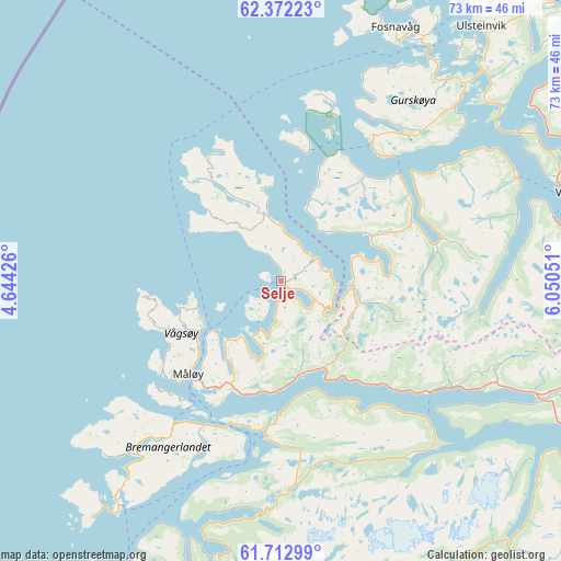
Selje GPS coordinates[2]
62° 2' 39.84" North, 5° 20' 50.604" East
| Map corner | latitude | longitude |
|---|---|---|
| Upper-left | 62.37223°, | 4.64426° |
| Center: | 62.0444°, | 5.34739° |
| Lower-right: | 61.71299°, | 6.05051° |
| Map W x H: | 73.3×73.3 km | = 45.5×45.5mi |
| max Lat: | 71.04137° ⇑35.8% North |
| Selje: | 62.0444° |
| min Lat: | ⇓64.2% South 58.0274° |
| min Long | Selje | max Long |
| 4.71485° | 5.34739° | 31.11066° |
| W 7%⇐ | ⇒93% E |
Elevation
Elevation of Selje is 15 m = 49 ft, and this is 89.2 m = 293 ft below average elevation for this country.
| Max E: |
897 m = 2943 ft | 73.9% |
| Avg. | 104.2 m = 342 ft | |
| Selje | 15 m = 49 ft | |
Min E: |
1 m = 3 ft | 26.1% |
See also: Norway elevation on elevation.city.
Geographical zone
Selje is located in North temperate zone (between Tropic of Cancer and the Arctic Circle). Distance of this North polar circle is 502.5 km =312.2 mi to North.| Distance of | km | miles | from Selje |
|---|---|---|---|
| North Pole | 3108.4 | 1931.5 | to North |
| Arctic Circle | 502.5 | 312.2 | to North |
| Tropic Cancer | 4292.8 | 2667.4 | to South |
| Equator | 6898.7 | 4286.7 | to South |


Nearby cities:
15 places around Selje: (largest is in red/bold)
• Fiskå
12.6 km =7.8 mi,  60°
60°
• Florø
52.1 km =32.4 mi,  198°
198°
• Fosnavåg
36.3 km =22.6 mi,  24°
24°
• Hareid
50.6 km =31.4 mi,  44°
44°
• Hornindal
62 km =38.5 mi,  97°
97°
• Larsnes
21.3 km =13.2 mi,  34°
34°
• Måløy
17.2 km =10.7 mi,  225°
225°
• Nordfjordeid
36.4 km =22.6 mi,  113°
113°
• Raudeberg
12.8 km =8 mi,  238°
238°
• Sandane
54.5 km =33.9 mi,  123°
123°
• Svelgen
30.7 km =19.1 mi,  185°
185°
• Ulsteinvik
42.2 km =26.2 mi, 38°
• Ulsteinvik weather pws station
42 km =26.1 mi, 37°
• Volda
39.3 km =24.4 mi,  73°
73°
• Ørsta
44.2 km =27.5 mi, 66°
Sources, notices
• [Note1] Compared only with cities in Norway existing in our database
• [Src1] Map data: © OpenStreetMap contributors (CC-BY-SA)
• [Src2] Other city data from geonames.org with taken over terms of usage.
• [Src3] Geographical zone / Annual Mean Temperature by Robert A. Rohde @ Wikipedia
