Sauland geodata
Sauland (Telemark) is a seat of a second-order administrative division; located in Norway in Europe/Oslo (GMT+2) time zone. In our database, there are 488 cities with bigger population. Compared to other cities in Norway, 75.6% of cities are located further ↑North; 60.6% of cities are located further →East and 64.4% of cities have lower elevation than Sauland. Note1


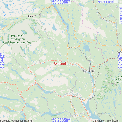
Sauland GPS coordinates[2]
59° 36' 57.96" North, 8° 56' 15.18" East
| Map corner | latitude | longitude |
|---|---|---|
| Upper-left | 59.96986°, | 8.23442° |
| Center: | 59.6161°, | 8.93755° |
| Lower-right: | 59.25858°, | 9.64067° |
| Map W x H: | 79.1×79.1 km | = 49.2×49.2mi |
| max Lat: | 71.04137° ⇑75.6% North |
| Sauland: | 59.6161° |
| min Lat: | ⇓24.4% South 58.0274° |
| min Long | Sauland | max Long |
| 4.71485° | 8.93755° | 31.11066° |
| W 39.4%⇐ | ⇒60.6% E |
Elevation
Elevation of Sauland is 89 m = 292 ft, and this is 15.2 m = 50 ft below average elevation for this country.
| Max E: |
897 m = 2943 ft | 35.6% |
| Avg. | 104.2 m = 342 ft | |
| Sauland | 89 m = 292 ft | |
Min E: |
1 m = 3 ft | 64.4% |
See also: Norway elevation on elevation.city.
Geographical zone
Sauland is located in North temperate zone (between Tropic of Cancer and the Arctic Circle). Distance of this North polar circle is 772.5 km =480 mi to North.| Distance of | km | miles | from Sauland |
|---|---|---|---|
| North Pole | 3378.4 | 2099.2 | to North |
| Arctic Circle | 772.5 | 480 | to North |
| Tropic Cancer | 4022.8 | 2499.7 | to South |
| Equator | 6628.7 | 4118.9 | to South |


Nearby cities:
15 places around Sauland: (largest is in red/bold)
• Bø
23.8 km =14.8 mi,  161°
161°
• Dalen
55.9 km =34.7 mi,  250°
250°
• Gvarv
28.6 km =17.8 mi,  152°
152°
• Kongsberg
40.5 km =25.2 mi,  81°
81°
• Kviteseid
34.6 km =21.5 mi,  226°
226°
• Lampeland
43.4 km =27 mi,  55°
55°
• Lunde
36.5 km =22.7 mi,  165°
165°
• Notodden
19.1 km =11.9 mi,  109°
109°
• Rjukan
35 km =21.7 mi,  326°
326°
• Rollag
45.6 km =28.3 mi,  26°
26°
• Seljord
22.7 km =14.1 mi, 229°
• Siljan
56.9 km =35.4 mi,  129°
129°
• Ulefoss
41.5 km =25.8 mi, 153°
• Åmot
32.2 km =20 mi,  273°
273°
• Åmot
53.6 km =33.3 mi,  264°
264°
Sources, notices
• [Note1] Compared only with cities in Norway existing in our database
• [Src1] Map data: © OpenStreetMap contributors (CC-BY-SA)
• [Src2] Other city data from geonames.org with taken over terms of usage.
• [Src3] Geographical zone / Annual Mean Temperature by Robert A. Rohde @ Wikipedia
