Ulefoss geodata
Ulefoss (Telemark) is a seat of a second-order administrative division; located in Norway in Europe/Oslo (GMT+2) time zone. With population of 2,697 people, there are 141 cities with bigger population in this country. Compared to other cities in Norway, 84.3% of cities are located further ↑North; 57.4% of cities are located further →East and 61.1% of cities have higher elevation than Ulefoss. Note1


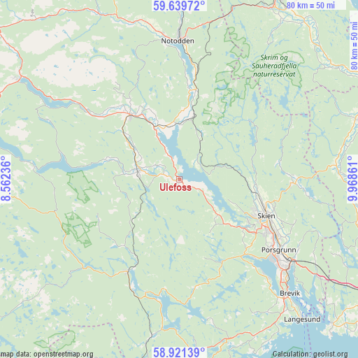
Ulefoss GPS coordinates[2]
59° 16' 56.82" North, 9° 15' 55.728" East
| Map corner | latitude | longitude |
|---|---|---|
| Upper-left | 59.63972°, | 8.56236° |
| Center: | 59.28245°, | 9.26548° |
| Lower-right: | 58.92139°, | 9.96861° |
| Map W x H: | 79.9×79.9 km | = 49.6×49.6mi |
| max Lat: | 71.04137° ⇑84.3% North |
| Ulefoss: | 59.28245° |
| min Lat: | ⇓15.7% South 58.0274° |
| min Long | Ulefoss | max Long |
| 4.71485° | 9.26548° | 31.11066° |
| W 42.6%⇐ | ⇒57.4% E |
Elevation
Elevation of Ulefoss is 26 m = 85 ft, and this is 78.2 m = 257 ft below average elevation for this country.
| Max E: |
897 m = 2943 ft | 61.1% |
| Avg. | 104.2 m = 342 ft | |
| Ulefoss | 26 m = 85 ft | |
Min E: |
1 m = 3 ft | 38.9% |
See also: Norway elevation on elevation.city.
Geographical zone
Ulefoss is located in North temperate zone (between Tropic of Cancer and the Arctic Circle). Distance of this North polar circle is 809.6 km =503.1 mi to North.| Distance of | km | miles | from Ulefoss |
|---|---|---|---|
| North Pole | 3415.5 | 2122.3 | to North |
| Arctic Circle | 809.6 | 503.1 | to North |
| Tropic Cancer | 3985.7 | 2476.6 | to South |
| Equator | 6591.6 | 4095.8 | to South |


Nearby cities:
15 places around Ulefoss: (largest is in red/bold)
• Bø
18.3 km =11.4 mi,  322°
322°
• Gvarv
12.8 km =8 mi,  335°
335°
• Herre
26.1 km =16.2 mi,  139°
139°
• Kil
43.5 km =27 mi,  177°
177°
• Kvelde
41.2 km =25.6 mi,  104°
104°
• Langangen
37.6 km =23.4 mi,  125°
125°
• Langesund
41.7 km =25.9 mi, 138°
• Lunde
9.4 km =5.8 mi,  280°
280°
• Notodden
30.8 km =19.1 mi,  359°
359°
• Porsgrunn
27.3 km =17 mi, 125°
• Prestestranda
23.7 km =14.7 mi,  209°
209°
• Sauland
41.5 km =25.8 mi,  333°
333°
• Seljord
42.4 km =26.3 mi,  302°
302°
• Siljan
25.3 km =15.7 mi,  88°
88°
• Skien
21.1 km =13.1 mi,  112°
112°
Sources, notices
• [Note1] Compared only with cities in Norway existing in our database
• [Src1] Map data: © OpenStreetMap contributors (CC-BY-SA)
• [Src2] Other city data from geonames.org with taken over terms of usage.
• [Src3] Geographical zone / Annual Mean Temperature by Robert A. Rohde @ Wikipedia
