Rollag geodata
Rollag (Buskerud) is a seat of a second-order administrative division; located in Norway in Europe/Oslo (GMT+2) time zone. In our database, there are 488 cities with bigger population. Compared to other cities in Norway, 65.2% of cities are located further ↑North; 57.1% of cities are located further →East and 85.8% of cities have lower elevation than Rollag. Note1


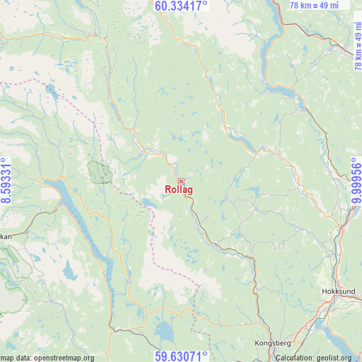
Rollag GPS coordinates[2]
59° 59' 3.516" North, 9° 17' 47.184" East
| Map corner | latitude | longitude |
|---|---|---|
| Upper-left | 60.33417°, | 8.59331° |
| Center: | 59.98431°, | 9.29644° |
| Lower-right: | 59.63071°, | 9.99956° |
| Map W x H: | 78.2×78.2 km | = 48.6×48.6mi |
| max Lat: | 71.04137° ⇑65.2% North |
| Rollag: | 59.98431° |
| min Lat: | ⇓34.8% South 58.0274° |
| min Long | Rollag | max Long |
| 4.71485° | 9.29644° | 31.11066° |
| W 42.9%⇐ | ⇒57.1% E |
Elevation
Elevation of Rollag is 208 m = 682 ft, and this is 103.8 m = 341 ft above average elevation for this country.
| Max E: |
897 m = 2943 ft | 14.2% |
| Rollag | 208 m 682 ft | |
| Avg. | 104.2 m = 342 ft | |
Min E: |
1 m = 3 ft | 85.8% |
See also: Norway elevation on elevation.city.
Geographical zone
Rollag is located in North temperate zone (between Tropic of Cancer and the Arctic Circle). Distance of this North polar circle is 731.5 km =454.5 mi to North.| Distance of | km | miles | from Rollag |
|---|---|---|---|
| North Pole | 3337.4 | 2073.8 | to North |
| Arctic Circle | 731.5 | 454.5 | to North |
| Tropic Cancer | 4063.7 | 2525.1 | to South |
| Equator | 6669.6 | 4144.3 | to South |


Nearby cities:
15 places around Rollag: (largest is in red/bold)
• Flå
50.4 km =31.3 mi,  10°
10°
• Hokksund
41.7 km =25.9 mi,  124°
124°
• Kongsberg
40.3 km =25 mi,  150°
150°
• Lampeland
22.9 km =14.2 mi,  136°
136°
• Mjøndalen
48.2 km =30 mi, 122°
• Noresund
28.3 km =17.6 mi,  39°
39°
• Notodden
47.3 km =29.4 mi,  182°
182°
• Prestfoss
19.9 km =12.4 mi,  70°
70°
• Rjukan
40.8 km =25.4 mi,  253°
253°
• Rødberg
36.9 km =22.9 mi,  328°
328°
• Sauland
45.6 km =28.3 mi,  206°
206°
• Sokna
45 km =28 mi,  51°
51°
• Tyristrand
45.9 km =28.5 mi,  75°
75°
• Vik
55.5 km =34.5 mi, 79°
• Vikersund
38.7 km =24 mi,  92°
92°
Sources, notices
• [Note1] Compared only with cities in Norway existing in our database
• [Src1] Map data: © OpenStreetMap contributors (CC-BY-SA)
• [Src2] Other city data from geonames.org with taken over terms of usage.
• [Src3] Geographical zone / Annual Mean Temperature by Robert A. Rohde @ Wikipedia
