Kongsberg geodata
Kongsberg (Buskerud) is a seat of a second-order administrative division; located in Norway in Europe/Oslo (GMT+2) time zone. With population of 17,667 people, there are 29 cities with bigger population in this country. Compared to other cities in Norway, 73.7% of cities are located further ↑North; 54.7% of cities are located further →East and 79% of cities have lower elevation than Kongsberg. Note1


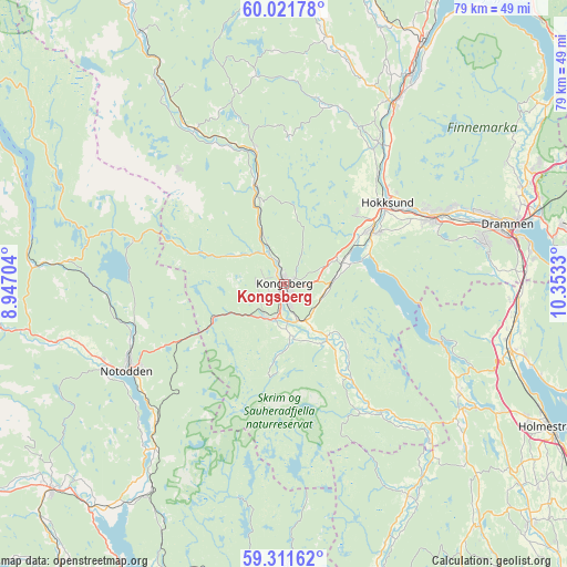
Kongsberg GPS coordinates[2]
59° 40' 6.888" North, 9° 39' 0.612" East
| Map corner | latitude | longitude |
|---|---|---|
| Upper-left | 60.02178°, | 8.94704° |
| Center: | 59.66858°, | 9.65017° |
| Lower-right: | 59.31162°, | 10.3533° |
| Map W x H: | 79×79 km | = 49.1×49.1mi |
| max Lat: | 71.04137° ⇑73.7% North |
| Kongsberg: | 59.66858° |
| min Lat: | ⇓26.3% South 58.0274° |
| min Long | Kongsberg | max Long |
| 4.71485° | 9.65017° | 31.11066° |
| W 45.3%⇐ | ⇒54.7% E |
Elevation
Elevation of Kongsberg is 161 m = 528 ft, and this is 56.8 m = 186 ft above average elevation for this country.
| Max E: |
897 m = 2943 ft | 21% |
| Kongsberg | 161 m 528 ft | |
| Avg. | 104.2 m = 342 ft | |
Min E: |
1 m = 3 ft | 79% |
See also: Norway elevation on elevation.city.
Geographical zone
Kongsberg is located in North temperate zone (between Tropic of Cancer and the Arctic Circle). Distance of this North polar circle is 766.6 km =476.3 mi to North.| Distance of | km | miles | from Kongsberg |
|---|---|---|---|
| North Pole | 3372.5 | 2095.6 | to North |
| Arctic Circle | 766.6 | 476.3 | to North |
| Tropic Cancer | 4028.6 | 2503.3 | to South |
| Equator | 6634.5 | 4122.5 | to South |


Nearby cities:
15 places around Kongsberg: (largest is in red/bold)
• Drammen
32.2 km =20 mi,  74°
74°
• Gullhaug
38.7 km =24 mi,  118°
118°
• Hokksund
18.5 km =11.5 mi,  52°
52°
• Hvittingfoss
28.8 km =17.9 mi,  134°
134°
• Lampeland
18.9 km =11.7 mi,  347°
347°
• Lierbyen
35.8 km =22.2 mi, 68°
• Mjøndalen
22.9 km =14.2 mi, 66°
• Notodden
25.2 km =15.7 mi,  241°
241°
• Rollag
40.3 km =25 mi,  330°
330°
• Sande
32.7 km =20.3 mi,  106°
106°
• Sauland
40.5 km =25.2 mi,  261°
261°
• Selvik
36.1 km =22.4 mi, 108°
• Skoger
34.2 km =21.3 mi,  81°
81°
• Tranby
37.6 km =23.4 mi, 65°
• Vikersund
38.4 km =23.9 mi,  29°
29°
Sources, notices
• [Note1] Compared only with cities in Norway existing in our database
• [Src1] Map data: © OpenStreetMap contributors (CC-BY-SA)
• [Src2] Other city data from geonames.org with taken over terms of usage.
• [Src3] Geographical zone / Annual Mean Temperature by Robert A. Rohde @ Wikipedia
