Rjukan geodata
Rjukan (Telemark) is a seat of a second-order administrative division; located in Norway in Europe/Oslo (GMT+2) time zone. With population of 3,568 people, there are 115 cities with bigger population in this country. Compared to other cities in Norway, 68.2% of cities are located further ↑North; 62.5% of cities are located further →East and 91.1% of cities have lower elevation than Rjukan. Note1


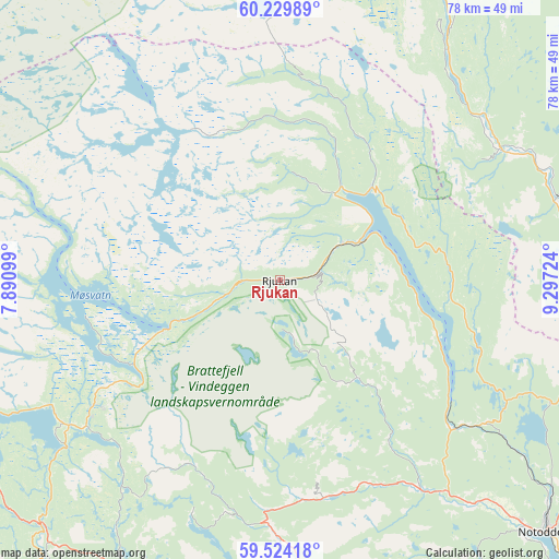
Rjukan GPS coordinates[2]
59° 52' 44.076" North, 8° 35' 38.796" East
| Map corner | latitude | longitude |
|---|---|---|
| Upper-left | 60.22989°, | 7.89099° |
| Center: | 59.87891°, | 8.59411° |
| Lower-right: | 59.52418°, | 9.29724° |
| Map W x H: | 78.5×78.5 km | = 48.8×48.8mi |
| max Lat: | 71.04137° ⇑68.2% North |
| Rjukan: | 59.87891° |
| min Lat: | ⇓31.8% South 58.0274° |
| min Long | Rjukan | max Long |
| 4.71485° | 8.59411° | 31.11066° |
| W 37.5%⇐ | ⇒62.5% E |
Elevation
Elevation of Rjukan is 302 m = 991 ft, and this is 197.8 m = 649 ft above average elevation for this country.
| Max E: |
897 m = 2943 ft | 8.9% |
| Rjukan | 302 m 991 ft | |
| Avg. | 104.2 m = 342 ft | |
Min E: |
1 m = 3 ft | 91.1% |
See also: Norway elevation on elevation.city.
Geographical zone
Rjukan is located in North temperate zone (between Tropic of Cancer and the Arctic Circle). Distance of this North polar circle is 743.3 km =461.9 mi to North.| Distance of | km | miles | from Rjukan |
|---|---|---|---|
| North Pole | 3349.2 | 2081.1 | to North |
| Arctic Circle | 743.3 | 461.9 | to North |
| Tropic Cancer | 4052 | 2517.8 | to South |
| Equator | 6657.9 | 4137 | to South |


Nearby cities:
15 places around Rjukan: (largest is in red/bold)
• Bø
58.3 km =36.2 mi,  152°
152°
• Dalen
58.5 km =36.4 mi,  214°
214°
• Gvarv
63.6 km =39.5 mi, 149°
• Kongsberg
63.6 km =39.5 mi,  111°
111°
• Kviteseid
53.3 km =33.1 mi,  186°
186°
• Lampeland
55.2 km =34.3 mi,  95°
95°
• Noresund
66.3 km =41.2 mi,  59°
59°
• Notodden
51.5 km =32 mi,  133°
133°
• Prestfoss
60.8 km =37.8 mi,  72°
72°
• Rollag
40.8 km =25.4 mi, 73°
• Rødberg
47.4 km =29.5 mi,  24°
24°
• Sauland
35 km =21.7 mi, 146°
• Seljord
43.9 km =27.3 mi,  177°
177°
• Åmot
30.1 km =18.7 mi, 205°
• Åmot
48.3 km =30 mi,  224°
224°
Sources, notices
• [Note1] Compared only with cities in Norway existing in our database
• [Src1] Map data: © OpenStreetMap contributors (CC-BY-SA)
• [Src2] Other city data from geonames.org with taken over terms of usage.
• [Src3] Geographical zone / Annual Mean Temperature by Robert A. Rohde @ Wikipedia
