Straume geodata
Straume (Hordaland) is a seat of a second-order administrative division; located in Norway in Europe/Oslo (GMT+2) time zone. In our database, there are 488 cities with bigger population. Compared to other cities in Norway, 56.2% of cities are located further ↑North; 97.6% of cities are located further →East and 52.7% of cities have higher elevation than Straume. Note1


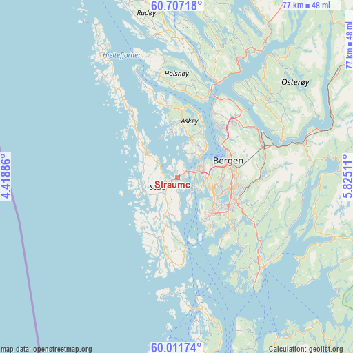
Straume GPS coordinates[2]
60° 21' 40.716" North, 5° 7' 19.164" East
| Map corner | latitude | longitude |
|---|---|---|
| Upper-left | 60.70718°, | 4.41886° |
| Center: | 60.36131°, | 5.12199° |
| Lower-right: | 60.01174°, | 5.82511° |
| Map W x H: | 77.3×77.3 km | = 48×48mi |
| max Lat: | 71.04137° ⇑56.2% North |
| Straume: | 60.36131° |
| min Lat: | ⇓43.8% South 58.0274° |
| min Long | Straume | max Long |
| 4.71485° | 5.12199° | 31.11066° |
| W 2.4%⇐ | ⇒97.6% E |
Elevation
Elevation of Straume is 40 m = 131 ft, and this is 64.2 m = 211 ft below average elevation for this country.
| Max E: |
897 m = 2943 ft | 52.7% |
| Avg. | 104.2 m = 342 ft | |
| Straume | 40 m = 131 ft | |
Min E: |
1 m = 3 ft | 47.3% |
See also: Norway elevation on elevation.city.
Geographical zone
Straume is located in North temperate zone (between Tropic of Cancer and the Arctic Circle). Distance of this North polar circle is 689.6 km =428.5 mi to North.| Distance of | km | miles | from Straume |
|---|---|---|---|
| North Pole | 3295.5 | 2047.7 | to North |
| Arctic Circle | 689.6 | 428.5 | to North |
| Tropic Cancer | 4105.6 | 2551.1 | to South |
| Equator | 6711.5 | 4170.3 | to South |


Nearby cities:
15 places around Straume: (largest is in red/bold)
• Askøy
5.5 km =3.4 mi,  38°
38°
• Bergen
11.7 km =7.3 mi,  72°
72°
• Espeland
19 km =11.8 mi,  82°
82°
• Frekhaug
18.1 km =11.2 mi,  21°
21°
• Hylkje
20.9 km =13 mi, 37°
• Indre Arna
20.2 km =12.6 mi, 71°
• Kleppestø
7.8 km =4.8 mi,  47°
47°
• Klokkarvik
15.3 km =9.5 mi,  174°
174°
• Knappskog
4.1 km =2.5 mi,  298°
298°
• Sandsli
11.1 km =6.9 mi,  125°
125°
• Skogsvågen
11.9 km =7.4 mi,  185°
185°
• Sollsvika
11.9 km =7.4 mi,  314°
314°
• Ytre Arna
20.4 km =12.7 mi,  56°
56°
• Ytrebygda
10.8 km =6.7 mi, 125°
• Ågotnes
7.3 km =4.5 mi, 309°
Sources, notices
• [Note1] Compared only with cities in Norway existing in our database
• [Src1] Map data: © OpenStreetMap contributors (CC-BY-SA)
• [Src2] Other city data from geonames.org with taken over terms of usage.
• [Src3] Geographical zone / Annual Mean Temperature by Robert A. Rohde @ Wikipedia
