Ytrebygda geodata
Ytrebygda (Hordaland) is a section of populated place; located in Norway in Europe/Oslo (GMT+2) time zone. With population of 24,044 people, there are 21 cities with bigger population in this country. Compared to other cities in Norway, 56.6% of cities are located further ↑North; 94.5% of cities are located further →East and 54.9% of cities have lower elevation than Ytrebygda. Note1


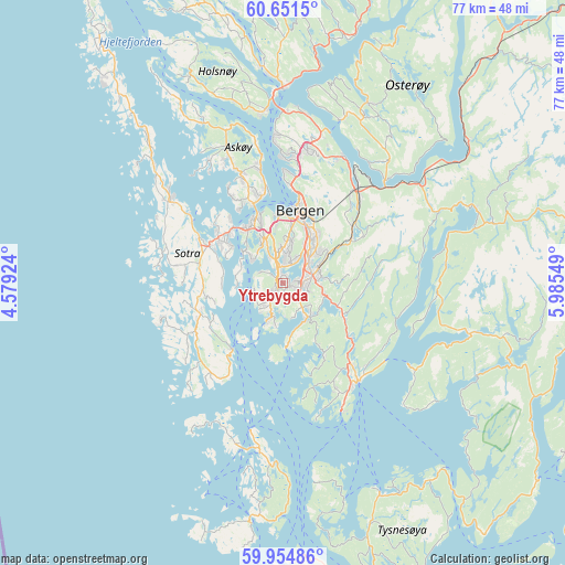
Ytrebygda GPS coordinates[2]
60° 18' 18.144" North, 5° 16' 56.496" East
| Map corner | latitude | longitude |
|---|---|---|
| Upper-left | 60.6515°, | 4.57924° |
| Center: | 60.30504°, | 5.28236° |
| Lower-right: | 59.95486°, | 5.98549° |
| Map W x H: | 77.5×77.5 km | = 48.2×48.2mi |
| max Lat: | 71.04137° ⇑56.6% North |
| Ytrebygda: | 60.30504° |
| min Lat: | ⇓43.4% South 58.0274° |
| min Long | Ytrebygda | max Long |
| 4.71485° | 5.28236° | 31.11066° |
| W 5.5%⇐ | ⇒94.5% E |
Elevation
Elevation of Ytrebygda is 60 m = 197 ft, and this is 44.2 m = 145 ft below average elevation for this country.
| Max E: |
897 m = 2943 ft | 45.1% |
| Avg. | 104.2 m = 342 ft | |
| Ytrebygda | 60 m = 197 ft | |
Min E: |
1 m = 3 ft | 54.9% |
See also: Norway elevation on elevation.city.
Geographical zone
Ytrebygda is located in North temperate zone (between Tropic of Cancer and the Arctic Circle). Distance of this North polar circle is 695.9 km =432.4 mi to North.| Distance of | km | miles | from Ytrebygda |
|---|---|---|---|
| North Pole | 3301.8 | 2051.6 | to North |
| Arctic Circle | 695.9 | 432.4 | to North |
| Tropic Cancer | 4099.4 | 2547.2 | to South |
| Equator | 6705.3 | 4166.5 | to South |


Nearby cities:
15 places around Ytrebygda: (largest is in red/bold)
• Askøy
11.9 km =7.4 mi,  332°
332°
• Bergen
10 km =6.2 mi,  13°
13°
• Espeland
13.3 km =8.3 mi,  49°
49°
• Hagavik
15.3 km =9.5 mi,  154°
154°
• Indre Arna
16.3 km =10.1 mi,  39°
39°
• Kleppestø
11.9 km =7.4 mi,  345°
345°
• Klokkarvik
11.5 km =7.1 mi,  219°
219°
• Knappskog
14.9 km =9.3 mi,  303°
303°
• Osøyro
16.8 km =10.4 mi,  143°
143°
• Sandsli
0.3 km =0.2 mi, 138°
• Skogsvågen
11.4 km =7.1 mi,  240°
240°
• Straume
10.8 km =6.7 mi,  305°
305°
• Syfteland
12 km =7.5 mi,  128°
128°
• Søvik
11.5 km =7.1 mi, 149°
• Ågotnes
18.1 km =11.2 mi, 306°
Sources, notices
• [Note1] Compared only with cities in Norway existing in our database
• [Src1] Map data: © OpenStreetMap contributors (CC-BY-SA)
• [Src2] Other city data from geonames.org with taken over terms of usage.
• [Src3] Geographical zone / Annual Mean Temperature by Robert A. Rohde @ Wikipedia
