Espeland geodata
Espeland (Hordaland) is a populated place; located in Norway in Europe/Oslo (GMT+2) time zone. With population of 1,793 people, there are 222 cities with bigger population in this country. Compared to other cities in Norway, 55.4% of cities are located further ↑North; 90.5% of cities are located further →East and 69.5% of cities have lower elevation than Espeland. Note1


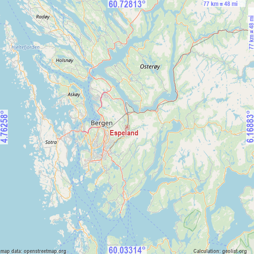
Espeland GPS coordinates[2]
60° 22' 56.964" North, 5° 27' 56.52" East
| Map corner | latitude | longitude |
|---|---|---|
| Upper-left | 60.72813°, | 4.76258° |
| Center: | 60.38249°, | 5.4657° |
| Lower-right: | 60.03314°, | 6.16883° |
| Map W x H: | 77.3×77.3 km | = 48×48mi |
| max Lat: | 71.04137° ⇑55.4% North |
| Espeland: | 60.38249° |
| min Lat: | ⇓44.6% South 58.0274° |
| min Long | Espeland | max Long |
| 4.71485° | 5.4657° | 31.11066° |
| W 9.5%⇐ | ⇒90.5% E |
Elevation
Elevation of Espeland is 120 m = 394 ft, and this is 15.8 m = 52 ft above average elevation for this country.
| Max E: |
897 m = 2943 ft | 30.5% |
| Espeland | 120 m 394 ft | |
| Avg. | 104.2 m = 342 ft | |
Min E: |
1 m = 3 ft | 69.5% |
See also: Norway elevation on elevation.city.
Geographical zone
Espeland is located in North temperate zone (between Tropic of Cancer and the Arctic Circle). Distance of this North polar circle is 687.3 km =427.1 mi to North.| Distance of | km | miles | from Espeland |
|---|---|---|---|
| North Pole | 3293.2 | 2046.3 | to North |
| Arctic Circle | 687.3 | 427.1 | to North |
| Tropic Cancer | 4108 | 2552.6 | to South |
| Equator | 6713.9 | 4171.8 | to South |


Nearby cities:
15 places around Espeland: (largest is in red/bold)
• Askøy
15.6 km =9.7 mi,  277°
277°
• Bergen
7.9 km =4.9 mi, 278°
• Hylkje
15.5 km =9.6 mi,  336°
336°
• Indra Haga
16.8 km =10.4 mi,  87°
87°
• Indre Arna
3.9 km =2.4 mi,  4°
4°
• Kleppestø
13.4 km =8.3 mi, 282°
• Lonevåg
16 km =9.9 mi,  5°
5°
• Sandsli
13.3 km =8.3 mi,  228°
228°
• Straume
19 km =11.8 mi,  262°
262°
• Syfteland
16.1 km =10 mi,  182°
182°
• Søvik
19 km =11.8 mi,  193°
193°
• Tysse
16.2 km =10.1 mi, 93°
• Vaksdal
18.4 km =11.4 mi,  55°
55°
• Ytre Arna
9 km =5.6 mi,  348°
348°
• Ytrebygda
13.3 km =8.3 mi, 229°
Sources, notices
• [Note1] Compared only with cities in Norway existing in our database
• [Src1] Map data: © OpenStreetMap contributors (CC-BY-SA)
• [Src2] Other city data from geonames.org with taken over terms of usage.
• [Src3] Geographical zone / Annual Mean Temperature by Robert A. Rohde @ Wikipedia
