Indre Arna geodata
Indre Arna (Hordaland) is a populated place; located in Norway in Europe/Oslo (GMT+2) time zone. With population of 6,117 people, there are 72 cities with bigger population in this country. Compared to other cities in Norway, 54% of cities are located further ↑North; 90.3% of cities are located further →East and 87.8% of cities have lower elevation than Indre Arna. Note1


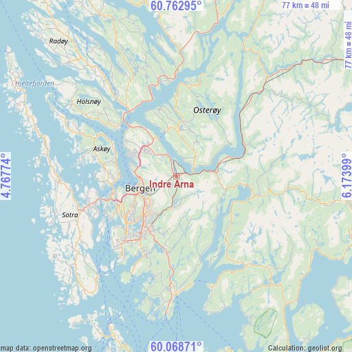
Indre Arna GPS coordinates[2]
60° 25' 3.648" North, 5° 28' 15.132" East
| Map corner | latitude | longitude |
|---|---|---|
| Upper-left | 60.76295°, | 4.76774° |
| Center: | 60.41768°, | 5.47087° |
| Lower-right: | 60.06871°, | 6.17399° |
| Map W x H: | 77.2×77.2 km | = 48×48mi |
| max Lat: | 71.04137° ⇑54% North |
| Indre Arna: | 60.41768° |
| min Lat: | ⇓46% South 58.0274° |
| min Long | Indre Arna | max Long |
| 4.71485° | 5.47087° | 31.11066° |
| W 9.7%⇐ | ⇒90.3% E |
Elevation
Elevation of Indre Arna is 234 m = 768 ft, and this is 129.8 m = 426 ft above average elevation for this country.
| Max E: |
897 m = 2943 ft | 12.2% |
| Indre Arna | 234 m 768 ft | |
| Avg. | 104.2 m = 342 ft | |
Min E: |
1 m = 3 ft | 87.8% |
See also: Norway elevation on elevation.city.
Geographical zone
Indre Arna is located in North temperate zone (between Tropic of Cancer and the Arctic Circle). Distance of this North polar circle is 683.4 km =424.6 mi to North.| Distance of | km | miles | from Indre Arna |
|---|---|---|---|
| North Pole | 3289.2 | 2043.8 | to North |
| Arctic Circle | 683.4 | 424.6 | to North |
| Tropic Cancer | 4111.9 | 2555 | to South |
| Equator | 6717.8 | 4174.2 | to South |


Nearby cities:
15 places around Indre Arna: (largest is in red/bold)
• Askøy
15.9 km =9.9 mi,  262°
262°
• Bergen
8.5 km =5.3 mi,  251°
251°
• Espeland
3.9 km =2.4 mi,  184°
184°
• Frekhaug
16.4 km =10.2 mi,  310°
310°
• Hylkje
12.1 km =7.5 mi,  328°
328°
• Indra Haga
16.8 km =10.4 mi,  101°
101°
• Isdalstø
18.9 km =11.7 mi,  324°
324°
• Kleppestø
13.4 km =8.3 mi,  265°
265°
• Knarvik
17.6 km =10.9 mi, 323°
• Lonevåg
12.1 km =7.5 mi,  6°
6°
• Sandsli
16.3 km =10.1 mi,  218°
218°
• Tysse
16.6 km =10.3 mi,  107°
107°
• Vaksdal
16.2 km =10.1 mi,  66°
66°
• Ytre Arna
5.3 km =3.3 mi,  336°
336°
• Ytrebygda
16.3 km =10.1 mi, 219°
Sources, notices
• [Note1] Compared only with cities in Norway existing in our database
• [Src1] Map data: © OpenStreetMap contributors (CC-BY-SA)
• [Src2] Other city data from geonames.org with taken over terms of usage.
• [Src3] Geographical zone / Annual Mean Temperature by Robert A. Rohde @ Wikipedia
