Kleppestø geodata
Kleppestø (Hordaland) is a seat of a second-order administrative division; located in Norway in Europe/Oslo (GMT+2) time zone. In our database, there are 488 cities with bigger population. Compared to other cities in Norway, 54.1% of cities are located further ↑North; 95.9% of cities are located further →East and 92.1% of cities have higher elevation than Kleppestø. Note1


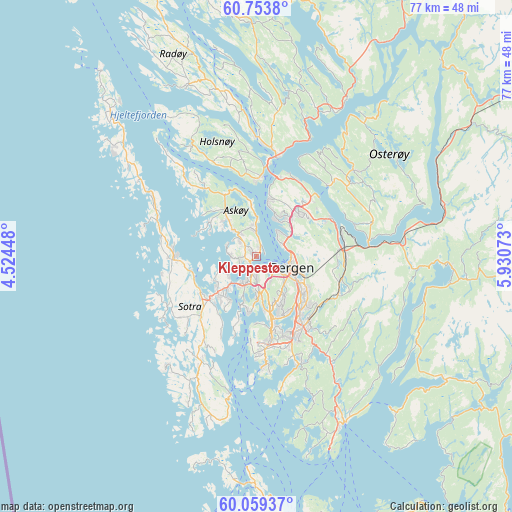
Kleppestø GPS coordinates[2]
60° 24' 30.384" North, 5° 13' 39.36" East
| Map corner | latitude | longitude |
|---|---|---|
| Upper-left | 60.7538°, | 4.52448° |
| Center: | 60.40844°, | 5.2276° |
| Lower-right: | 60.05937°, | 5.93073° |
| Map W x H: | 77.2×77.2 km | = 48×48mi |
| max Lat: | 71.04137° ⇑54.1% North |
| Kleppestø: | 60.40844° |
| min Lat: | ⇓45.9% South 58.0274° |
| min Long | Kleppestø | max Long |
| 4.71485° | 5.2276° | 31.11066° |
| W 4.1%⇐ | ⇒95.9% E |
Elevation
Elevation of Kleppestø is 3 m = 10 ft, and this is 101.2 m = 332 ft below average elevation for this country.
| Max E: |
897 m = 2943 ft | 92.1% |
| Avg. | 104.2 m = 342 ft | |
| Kleppestø | 3 m = 10 ft | |
Min E: |
1 m = 3 ft | 7.9% |
See also: Norway elevation on elevation.city.
Geographical zone
Kleppestø is located in North temperate zone (between Tropic of Cancer and the Arctic Circle). Distance of this North polar circle is 684.4 km =425.3 mi to North.| Distance of | km | miles | from Kleppestø |
|---|---|---|---|
| North Pole | 3290.3 | 2044.5 | to North |
| Arctic Circle | 684.4 | 425.3 | to North |
| Tropic Cancer | 4110.9 | 2554.4 | to South |
| Equator | 6716.8 | 4173.6 | to South |


Nearby cities:
15 places around Kleppestø: (largest is in red/bold)
• Askøy
2.6 km =1.6 mi,  248°
248°
• Bergen
5.6 km =3.5 mi,  107°
107°
• Espeland
13.4 km =8.3 mi,  102°
102°
• Frekhaug
11.7 km =7.3 mi,  4°
4°
• Hylkje
13.3 km =8.3 mi,  31°
31°
• Indre Arna
13.4 km =8.3 mi,  85°
85°
• Isdalstø
16.5 km =10.3 mi,  7°
7°
• Knappskog
10 km =6.2 mi, 250°
• Knarvik
15.5 km =9.6 mi, 11°
• Sandsli
12.1 km =7.5 mi,  164°
164°
• Sollsvika
14.7 km =9.1 mi,  282°
282°
• Straume
7.8 km =4.8 mi,  227°
227°
• Ytre Arna
12.7 km =7.9 mi,  62°
62°
• Ytrebygda
11.9 km =7.4 mi,  165°
165°
• Ågotnes
11.5 km =7.1 mi,  267°
267°
Sources, notices
• [Note1] Compared only with cities in Norway existing in our database
• [Src1] Map data: © OpenStreetMap contributors (CC-BY-SA)
• [Src2] Other city data from geonames.org with taken over terms of usage.
• [Src3] Geographical zone / Annual Mean Temperature by Robert A. Rohde @ Wikipedia
