Hawera geodata
Hawera (Taranaki) is a populated place; located in New Zealand in Pacific/Auckland (GMT+12) time zone. With population of 11,068 people, there are 39 cities with bigger population in this country. Compared to other cities in New Zealand, 51.7% of cities are located further ↓South; 53.6% of cities are located further →East and 77.8% of cities have lower elevation than Hawera. Note1


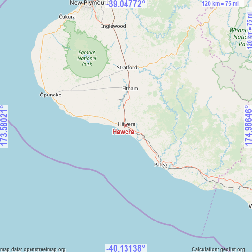
Hawera GPS coordinates[2]
39° 35' 30.012" South, 174° 16' 59.988" East
| Map corner | latitude | longitude |
|---|---|---|
| Upper-left | -39.04772°, | 173.58021° |
| Center: | -39.59167°, | 174.28333° |
| Lower-right: | -40.13138°, | 174.98646° |
| Map W x H: | 120.5×120.5 km | = 74.9×74.9mi |
| max Lat: | -34.99604° ⇑48.3% North |
| Hawera: | -39.59167° |
| min Lat: | ⇓51.7% South -46.6° |
| min Long | Hawera | max Long |
| -176.55973° | 174.28333° | 178.33333° |
| W 46.4%⇐ | ⇒53.6% E |
Elevation
Elevation of Hawera is 110 m = 361 ft, and this is 25.6 m = 84 ft above average elevation for this country.
| Max E: |
819 m = 2687 ft | 22.2% |
| Hawera | 110 m 361 ft | |
| Avg. | 84.4 m = 277 ft | |
Min E: |
3 m = 10 ft | 77.8% |
See also: New Zealand elevation on elevation.city.
Geographical zone
Hawera is located in South temperate zone (between Tropic of Capricorn and the Antarctic Circle). Distance of this Southern Tropic circle is 1796.3 km =1116.2 mi to North.| Distance of | km | miles | from Hawera |
|---|---|---|---|
| Equator | 4402.2 | 2735.4 | to North |
| Tropic Capricorn | 1796.3 | 1116.2 | to North |
| Antarctic Circle | 2999 | 1863.5 | to South |
| South Pole | 5604.9 | 3482.7 | to South |


Nearby cities:
15 places around Hawera: (largest is in red/bold)
• Bulls
114.2 km =71 mi,  124°
124°
• Eltham
18.1 km =11.2 mi,  4°
4°
• Himatangi
125.8 km =78.2 mi,  135°
135°
• Hunterville
116.3 km =72.3 mi,  109°
109°
• Manaia
13.7 km =8.5 mi,  289°
289°
• New Plymouth
60.9 km =37.8 mi,  343°
343°
• Okato
55.5 km =34.5 mi,  321°
321°
• Opunake
39.5 km =24.5 mi, 292°
• Patea
25.2 km =15.7 mi, 137°
• Rongotea
124.7 km =77.5 mi,  128°
128°
• Sanson
119.8 km =74.4 mi, 125°
• Waiouru
119.4 km =74.2 mi,  83°
83°
• Waitara
65.7 km =40.8 mi,  356°
356°
• Wanganui
75.7 km =47 mi, 120°
• Waverley
35.7 km =22.2 mi, 123°
Sources, notices
• [Note1] Compared only with cities in New Zealand existing in our database
• [Src1] Map data: © OpenStreetMap contributors (CC-BY-SA)
• [Src2] Other city data from geonames.org with taken over terms of usage.
• [Src3] Geographical zone / Annual Mean Temperature by Robert A. Rohde @ Wikipedia
